12. introduction
12.1 Objectives of this Assignment
12.1.1 The objectives of the Cultural Heritage Impact Assessment (CHIA) are to:
(b) To assess potential direct and indirect impacts arising from proposed development in Sub-Areas 1-4, and within the Study Area (Proposed Development Area (PDA) and 500m area extended from the boundary of the PDA); and
(c) To identify possible mitigation measures for adverse project impacts on heritage from the proposed development in Sub-Areas 1-4.
12.1.2 The purpose of this CHIA study is to provide information on the nature and extent of cultural heritage impacts arising from the construction and operation of the in Sub-Area 1, minor works in Sub-Areas 2 to 4 and associated infrastructure works. Details on proposed development are presented in Chapter 2, Section 2.8.
12.1.3 Depending on cultural heritage issues within the Sub-Area 1 and Sub-Areas 2 to 4, further detailed cultural heritage assessment at Investigation (Archaeology) and/or Design Stages (Built heritage) may be required pending information regarding detailed design, construction methods and associated works.
12.2 Legislation, Standards and Criteria
12.2.1 Introduction
12.2.1.1 Legislation, standards, guidelines and criteria relevant to the consideration of Archaeological and Built Heritage Impact Assessment studies under the EIA include the following;
· Antiquities and Monuments Ordinance (Cap.53);
· Environmental Impact Assessment Ordinance (EIAO) (Cap.499); including Technical Memorandum on Environmental Impact Assessment Process (TM-EIAO) and Guidelines for Cultural Heritage Impact Assessment;
· Hong Kong Planning Standards and Guidelines (HKPSG);
· Development Bureau Technical Circular (Works) No. 6/2009: Heritage Impact Assessment Mechanism for Capital Works Projects; and
· Proposed Grading and Graded Historic Buildings Classification.
12.2.2 Antiquities and Monuments Ordinance (Cap.53)
12.2.2.1 The Antiquities and Monuments Ordinance (the Ordinance) provides the statutory framework to provide for the preservation of objects of historical, archaeological and paleontological interest. The Ordinance contains the statutory procedures for the Declaration of Monuments. The proposed monument can be any place, building, site or structure, which is considered to be of public interest by reason of its historical, archaeological or paleontological significance.
12.2.2.2 Under Section 6 and subject to sub-section (4) of the Ordinance, the following acts are prohibited in relation to certain monuments, except under permit:
· To excavate, carry on building works, plant or fell trees or deposit earth or refuse on or in a proposed monument or monument; and
· To demolish, remove, obstruct, deface or interfere with a proposed monument or monument.
12.2.2.3 The discovery of an Antiquity, as defined in the Ordinance (heritage which pre-dates 1800) must be reported to the Antiquities Authority (the Authority), or a designated person. The Ordinance also provides that, the ownership of every relic discovered in Hong Kong after the commencement of this Ordinance shall vest in the Government from the moment of discovery. The Authority on behalf of the Government may disclaim ownership of the relic.
12.2.2.4 No archaeological excavation may be carried out by any person, other than the Authority and the designated person, without a licence issued by the Authority. A licence will only be issued if the Authority is satisfied that the applicant has sufficient scientific training or experience to enable him to carry out the excavation and search satisfactorily, is able to conduct, or arrange for, a proper scientific study of any antiquities discovered as a result of the excavation and search and has sufficient staff and financial support.
12.2.2.5 It should also be noted that the discovery of an antiquity under any circumstances must be reported to the Authority, i.e. the Secretary for Development or designated person. The Authority may require that the antiquity or suspected antiquity is identified to the Authority and that any person who has discovered an antiquity or suspected antiquity should take all reasonable measures to protect it.
12.2.3 Environmental Impact Assessment Ordinance (Cap.499)
12.2.3.1 The EIAO was implemented on 1 April 1998. Its purpose is to avoid, minimise and control the adverse impact on the environment of designated projects, through the application of the EIA process and the Environmental Permit (EP) system.
12.2.3.2 Technical Memorandum on Environmental Impact Assessment Process
The general criteria and guidelines for evaluating and assessing impacts to Sites of Cultural Heritage are listed in Annexes 10 and 19 of the Technical Memorandum on Environmental Impact Assessment Process TM-EIAO. It is stated in Annex 10 that all adverse impacts to Sites of Cultural Heritage should be kept to an absolute minimum and that the general presumption of impact assessment should be in favour of the protection and conservation of all Sites of Cultural Heritage. Annex 19 provides the details of scope and methodology for undertaking Cultural Heritage Impact Assessment, including baseline study, impact assessment and mitigation measures.
12.2.4 Guidelines for Cultural Heritage Impact Assessment
12.2.4.1 This document outlines the specific technical requirement for conducting terrestrial archaeological and built heritage impact assessments and is based upon the requirements of the TM-EIAO. It includes the parameters and scope for the Baseline Study, specifically desk-based research and field evaluation. Besides, it also includes included guidelines encompassing reporting requirements and archive preparation and submission in the form of Guidelines for Archaeological Reports and Guidelines for the Handling of Archaeological Finds and Archives.
12.2.4.2 The prerequisite conditions for conducting impact assessment and mitigation measures are presented in detail, including the prediction and evaluation of impacts based upon five levels of significance (Beneficial, Acceptable, Acceptable with Mitigation Measures, Unacceptable and Undetermined). The guidelines also state that preservation in totality must be taken as the first priority and if this is not feasible due to site constraints or other factors, full justification must be provided.
12.2.4.3 Mitigation measures will be proposed in cases with identified impacts and shall have the aim of minimising the degree of adverse impact and also where applicable providing enhancement to a heritage site through means such as enhancement of the existing environment or improvement to accessibility of heritage sites. The responsibility for the implementation of any proposed mitigation measures must be clearly stated with details of when and where the measures will be implemented and by whom.
12.2.5 Hong Kong Planning Standards and Guidelines
12.2.5.1 Chapter 10 of the HKPSG details the planning principles for the conservation of natural landscape and habitats, historical buildings and Sites of Archaeological Interest. The document states that the retention of significant heritage features should be adopted through the creation of conservation zones within which uses should be restricted to ensure the sustainability of the heritage features. The guidelines state that the concept of conservation of heritage features, should not be restricted to individual structures, but should endeavour to embrace the setting of the feature or features in both urban and rural settings.
12.2.5.2 The guidelines also address the issue of the preparation of plans for the conservation of historical buildings, Sites of Archaeological Interest and other antiquities. It is noted that the existing Declared Monuments and proposed Monuments be listed in the explanatory notes of Statutory Town Plans and that it be stated that prior consultation with AMO is necessary for any redevelopment or rezoning proposals affecting the Monuments and their surrounding environments.
12.2.5.3 It is also noted that planning intention for non-statutory town plans at the sub-regional level should be include the protection of monuments, historical buildings, Sites of Archaeological Interest and other antiquities through the identification of such features on sub-regional layout plans. The appendices list the legislation and administrative controls for conservation, other conservation related measures in Hong Kong, and Government departments involved in conservation.
12.2.6 Development Bureau Technical Circular (Works) No. 6/2009: Heritage Impact Assessment Mechanism for Capital Works Projects
12.2.6.1 This technical circular contains the procedures and requirements for assessing heritage impact arising from the implementation of new capital works projects. It is stated in the document that the works agent will provide a checklist to the AMO of any heritage sites (as defined in the technical circular) situated within or within the vicinity of the project boundary (usually to be defined as not more than 50 metres measured from the nearest point of the project boundary, including works areas).
12.2.6.2 The identification of the heritage sites should be undertaken at the earliest possible stage, preferably as part of the Technical Feasibility Statement. If the works boundary cannot be defined at this stage, the checklist should be provided as soon as the project boundary has been defined. Upon receipt of the above information from the works agent, the AMO will determine if the proposed project will affect the heritage value of any heritage site and decide the necessity of conducting a Heritage Impact Assessment (HIA) based upon the submitted information.
12.2.6.3 If a HIA is required, the works agent shall submit a proposal for the scope of the HIA for AMO approval. Once the scope has been approved it will be the responsibility of the works agent to conduct the HIA. Checklist for the project was submitted.
12.2.7 Proposed Grading and Graded Historic Buildings Classification
12.2.7.1 A grading system has been in place as a Government administration mechanism for classifying historic buildings based on heritage significance since the 1980’s. Currently the Antiquities Advisory Board is completing the task of assessing 1,444 historic buildings. There are three grades which are defined as follows;
· Grade 1. Grade-1 buildings are those of outstanding merits, of which every effort should be made for preservation if possible;
· Grade 2. Grade-2 buildings are those of special merits, of which efforts should be made for selective preservation; and
· Grade 3. Grade-3 buildings are those of some merits, of which preservation in some form would be desirable and alternative means could be considered if preservation is not practicable.
12.2.8 The system is not established under any legislation and graded buildings are not under any statutory protection unlike Declared Monuments.
12.2.8.1 Alongside assessment of the 1,444 historic buildings, the Antiquities Advisory Board (AAB) will also consider the heritage value and grading of the New Items proposed by the public for assessment.
12.3 Cultural Heritage Impact Assessment Methodology
12.3.1 The Cultural Heritage Impact Assessment includes Built Heritage Impact Assessment (BHIA) and Archaeological Impact Assessment (AIA). The Study Area for the BHIA and AIA is stated in the EIA Study Brief (ESB-318/2019) and set at 500m from the project boundary. The scope, approach and methodology for undertaken both built heritage and archaeological impact assessments is set out in the Guidelines for Cultural Heritage Impact Assessment and fulfil the relevant requirements as set out in Annexes 10 and 19 of the Technical Memorandum on the EIA process (TM-EIAO).
12.3.2 Built heritage impact assessment methodology
Key Issue
12.3.2.1 The key issues under built heritage within the PDA and Study Area (which includes PDA and additional 500m area extended from the boundary of the PDA) are four graded historic buildings, namely the Clubhouse of The Hong Kong Golf Club Fanling Golf Course (Grade 2), Half-way House of The Hong Kong Golf Club Fanling Golf Course (Grade 3), the Fanling Lodge (Grade 1), and No.5 Ng Uk Tsuen (Grade 3).
12.3.2.2 In addition, potential built structures associated with Old Course (constructed by 1911), and not-graded historic buildings and structures and will be mentioned under built heritage impact assessment. Clan graves, some which are antiquities under A&M Ordinance (Cap.53) and others part of group value will be mentioned separately.
Baseline Study
12.3.2.3 A desk-based study will be undertaken to determine the presence of other built heritage resources which fall under Section 3.2.3 below and glean further information on the above identified built heritage in the Study Area (PDA and 500m area extended from the boundary of the PDA). Research will include gathering information from the following sources:
· List of Declared Monuments and Graded Historic Buildings;
· List of New Items for grading assessment;
· Published and unpublished papers and studies;
· Publications on relevant historical, anthropological and other cultural studies;
· Unpublished archival, papers, records; collections and libraries of tertiary institutions;
· Historical documents which can be found in Public Records Office, Lands Registry, District Lands Office, District Office, Museum of History;
· Cartographic and pictorial documentation; and
· Previous Built Heritage Impact Assessment’s (BHIA) in the project Study Area.
Built Heritage Survey
12.3.2.4 The purpose of the built heritage survey is to identify all built heritage resources within or near the PDA (i.e. Study Area) if the information of the desk-based study is insufficient. The BHIA survey must adhere to the above cited guidelines and provide adequate information to fulfil the relevant requirements as set out in Annexes 10 and 19 of the Technical Memorandum on the EIA process (TM-EIAO). A Built heritage survey typically involves:
a. Field scan of all the historic buildings/structures/sites within the project area.
b. Photographic recording of each historic building/ structure/site including the exterior (the elevations of all faces of the building premises, the roof, close up for the special architectural details) and the interior (special architectural details), if possible, as well as the surroundings, the associated cultural landscape features and the associated intangible cultural heritage (if any) of each historic building/structure/site.
c. Interview with local elders and other informants (such as golf course users and operators) on local historical, architectural, anthropological and other cultural information related to the historic buildings and structures.
d. Historical and architectural appraisal of the historic buildings/ structures/ sites, their associated cultural landscape and intangible cultural elements.
12.3.2.5 The scope of the survey for this project will include all areas within the Study Area. The Study Area is considered sufficient for the determination of indirect impacts such as visual and damage from ground borne vibration, ground settlement or contact with machinery and equipment.
12.3.2.6 The scope of the items to be included in the built heritage survey should follow the Guidelines for Cultural Heritage Impact Assessment and compile a comprehensive inventory of heritage sites within the Study Area (as shown in Figure 1). The surveyed resources shall include:
ü all declared monuments;
ü all proposed monuments;
ü all buildings/ structures/ sites graded or proposed to be graded by the Antiquities Advisory Board (AAB);
ü New Items pending for grading assessment by AAB;
ü Government historic sites identified by AMO;
ü buildings/ structures/ sites of high architectural / historical significance and interest which are not included in items (i) to (iv) above; and
ü cultural landscapes include places associated with historic event, activity, or person or exhibiting other cultural or aesthetic values, such as sacred religious sites, battlefields, a setting for buildings or structures of architectural or archaeological importance, historic field patterns, clan graves, old tracks, fung shui woodlands and ponds, and etc.
12.3.2.7 The information gathered from the built heritage survey will be used to identify impacts and prepared mitigation recommendations (where necessary) for all of the resources identified in the survey.
12.3.2.8 The coding method for the recording of built heritage resources will be as follows:
Ø Declared Monument (DM);
Ø Graded Historic Building (GB);
Ø New Items/proposed to be graded (N); and
Ø Other Built Heritage Item (HB).
12.3.2.9 Clan graves will receive the code: G.
Impact Assessment and Mitigation Measures
12.3.2.10 Assessment of impacts on heritage sites shall also take full account of, and follow where appropriate, paragraph 4.3.1(c), item 2 of Annex 10, items 2.6 to 2.9 of Annex 19 and other relevant parts of the TM on EIA Process, including Guidelines for Landscape and Visual Impact Assessment of Annex 18 of the EIAO-TM. Identification of both direct and indirect impacts that may affect the built heritage resources within the Study Area will be undertaken. Potential impacts during the construction and operational phases may range from visual impacts, degrading of environmental setting of built heritage, ground borne vibration, settlement and tilting impacts, contact with equipment, limiting of access to built heritage, etc. Preservation in-situ will always be the first priority for sites of Cultural Heritage. If preservation in totality is not practicable, mitigation will be proposed to minimize the degree of adverse impact to the greatest possible extent. Besides, any disturbance to sites of Cultural Heritage that may cause physical damage should be avoided wherever practicable through alteration of design, construction method or protective measures as appropriate.
12.3.2.11 The following classification of impact will be used:
Beneficial Impact: The impact is beneficial if the project will enhance the preservation of the heritage site(s);
Acceptable Impact: If the assessment indicates that there will be no significant effects on the heritage site(s);
Acceptable Impact with Mitigation: If there will be some adverse effects, but if these can be eliminated, reduced or offset to a large extent by specific measures, such as conduct a follow-up Conservation Proposal or Conservation Management Plan for the affected heritage site(s) before commencement of work in order to avoid any inappropriate or unnecessary interventions to the building;
Unacceptable Impact: If the adverse effects are considered to be too excessive and are unable to mitigate practically; and
Undetermined Impact: If the significant adverse effects are likely, but the extent to which they may occur or may be mitigated cannot be determined from the study. Further detailed study will be required for the specific effects in question.
12.3.3 Archaeological Impact Assessment methodology
12.3.3.1 In accordance with the EIA Study Brief (ESB-318/2019) a qualified archaeologist was engaged to undertake the archaeological impact assessment (AIA). As stated in the Guidelines for Archaeological Impact Assessment (AMO May 2020), the baseline study is used to compile a comprehensive inventory of all sites of archaeological interest and to carry out archaeological survey (if possible) to assess the archaeological potential in case the available information is inadequate within Study Area (Figure 1).
12.3.3.2 The identified key issues for archaeology include one known site of archaeological interest within the Study Area, namely Po Leng Site of Archaeological Interest. Furthermore, Ping Kong village has a settlement history dating back to the Late Ming- Early Qing dynasty and previous archaeological investigation recovered such materials to the northwest of the village. Both while outside of the PDA are indicative of wider archaeological potential and historical use of the area.
12.3.3.3 The following tasks are undertaken in order to gather the necessary information for the compilation of the baseline study and assessment:
Task 1: Desk-based research
12.3.3.4 Firstly, desk-based research is carried out in order to describe known and identify potential sites of archaeological interest within the Study Area and to evaluate the cultural significance of these sites and areas. The area within the golf course is archaeologically under-researched and detailed desk- based research of potential for archaeology, including topographical, geological background, and existing impacts will be undertaken as part of this first task.
12.3.3.5 The following is a non-exhaustive list of resources that are consulted as part of the research programme:
Ø AMO published and unpublished papers and studies;
Ø Publications on relevant historical, anthropological and other cultural studies;
Ø Unpublished archival papers and records;
Ø Collections and libraries of tertiary institutions;
Ø Historical documents held in the Public Records Office, Lands Registry, District Lands Office, District Office and Museum of History;
Ø Cartographic and pictorial documentation; and
Ø Geotechnical information.
Task 2: Site visit
12.3.3.6 To supplement the information gathered in the desk-based study, a site visit was undertaken to assess the current status of the Study Area and also to make note of existing impacts.
Task 3: Archaeological Survey (if required)
12.3.3.7 If the results of the desk-based study and site visit indicate that there is insufficient data for purposes of identification of areas of archaeological potential, determination of cultural significance and assessment of impacts, an archaeological survey programme will be designed and submitted to the AMO for approval.
12.3.3.8 Appropriate methods for pricing and valuation of the archaeological survey, including by means of a Bill of Quantities or a Schedule of Rates should be adopted when appropriate in preparing specifications and relevant documents for calling tenders to carry out the archaeological survey. The specifications and relevant documents should be sent to the Antiquities and Monuments Office for agreement prior to calling tenders to conduct the archaeological survey.
12.3.3.9 The archaeologists should adhere to recognized standards for professional practice and ethical conduct in undertaking commissioned archaeological works under contracts. They should make themselves fully understand recognized principles and guidelines regarding contract archaeological works, such as those of the Chartered institute for Archaeologists, European Association of Archaeologists and in Mainland China. A qualified archaeologist shall apply for a licence under the Antiquities and Monuments Ordinance (Cap. 53) to undertake the archaeological survey. It takes at least two months to process the application.
12.3.3.10 An archaeological action plan, an outline framework of the proposed archaeological works, should be prepared. The archaeological action plan should clearly state the project and archaeological background, address necessary archaeological works required, elaborate the strategy and methodology adopted, including what particular question(s) can be resolved, how the archaeological data will be collected and recorded, how the evidence will be analyzed and interpreted and how the archaeological finds and results will be organized and made available. Effective field techniques including method and sampling details are required to be demonstrated in the archaeological action plan. Monitoring arrangement, reporting and contingency plan for field and post-excavation works and archive deposition (including finds, field and laboratory records, etc.) should be addressed in the archaeological action plan. The archaeological action plan should be submitted to AMO for agreement prior to applying for a licence. Prior visit to the project site before submission of the archaeological plan is required to ascertain the feasibility of the proposed strategy and methodology as well as the availability of the proposed locations for auger survey and test pitting.
12.3.3.11 The following methods of archaeological survey (but not limited to) should be applied to assess the archaeological potential of the project area:
Ø Definition of areas of natural land undisturbed in the recent past.
Ø Field scan of the natural land undisturbed in the recent past in detail with special attention paid to areas of exposed soil which were searched for artefacts.
Ø Conduct systematic auger survey and test pitting. The data collected from auger survey and test pitting should be able to establish the horizontal spread of cultural materials deposits.
Ø Excavation of test pits to establish the vertical sequence of cultural materials. The hand digging of 1 x 1 m or 1.5 x 1.5 m test pits to determine the presence or absence of deeper archaeological deposits and their cultural history.
Ø The quantity and location of auger holes and test pits should be agreed with the AMO prior to applying for a licence. Additional auger holes and test pits may be required to ascertain and demarcate the extent of archaeological deposit and remains.
Ø A qualified land surveyor should be engaged to record reduced levels and coordinates as well as setting base points and reference lines in the course of the field survey.
Ø All archaeological works should be properly completed and recorded to agreed standards.
12.3.3.12 If the field evaluation identifies any additional heritage sites within the study area which is of potential historic or archaeological importance/interest and not recorded by AMO, the findings should be reported to the AMO as soon as possible.
Task 4: Impact Assessment
12.3.3.13 The prediction and evaluation of both direct and indirect impacts will be undertaken to identify any potential adverse effects to all identified sites or potential areas of archaeological interest within the Study Area. Potential impacts to archaeology are mainly associated with direct impacts such as site formation and excavation within the development area, indirect impacts from utilities works, borrow areas, change of hydrology or surface pressure on features and deposits, however, may occur within the PDA and surrounding. Although detailed description of the works and associated plans which illustrate the nature and degree of potential impacts is unknown at this feasibility stage, assessment will be based on development option and the understanding of site formation and major construction activities. The impact assessment will adhere to the requirements of Annexes 10 and 19 of the EIAO-TM.
Task 5: Mitigation Measures
12.3.3.14 As stated in the Guidelines for Archaeological Impact Assessment “Preservation in totality must be taken as the first priority”. Only when such preservation is proved not feasible, as in the case where the need for a particular development can be shown to be of paramount importance on and it outweighs the significance of the area or site of archaeological interest, a programme of mitigation measures will be designed and submitted to the AMO for agreement. The mitigation measures should be clearly listed and the party responsible for implementation and timing of the measures will also be included. Mitigation measures may include further survey, rescue excavation, archaeological watching brief (AWB) and so forth.
12.4 Cultural heritage Baseline review
The baseline review provides background information on both archaeology and built heritage. The descriptions are provided for the PDA (Sub-Areas 1-4) and wider Study Area.
12.4.1 Geological and topographical background
12.4.1.1 The geology of the Study Area (PDA and the 500m area extended from the boundary of the PDA) consists of Pleistocene terraced alluvium and debris flow, bordered by coarse ash crystal tuff (Figure 2). The PDA lies at the edge of an inland valley and consists of small hillocks within an undulating landscape, reinforced, no doubt, by the golf course landscaping of bunkers, sandpits and tee offs. The wider Study Area occupies similar area and includes the inland valley situated along the east.
12.4.1.2 The topography within the PDA lies at elevations between 14.6 and 39mPD on hillocks and ranges more pronounced within the Study Area between 6.0mPD (low-lying debris flow deposits at the north) and 96.2mPD (the hillocks to the south and west). It is assumed that the original landscape has been modified by the construction of the golf course. The record of golf course design, original and subsequent changes, seems to have survived only in (old and aerial) photography, stories and descriptive form (see Section 4.2).
12.4.2 Historical background
12.4.2.1 There are no historical villages within the PDA, however, the Fanling Golf Course itself was first constructed in early 20th century, is as such over 100 years and should be considered a heritage place in itself. Within the wider Study Area, there are two historical villages; Ping Kong and Lin Tong Mei. Brief descriptions for golf course and historical villages follows:
The Hong Kong Golf Club Fanling Golf Course
12.4.2.2 The Fanling Golf Course (FGC), ran by Hong Kong Golf Club (HKGC, previously referred as Royal Hong Kong Golf Club), has a history over 100 years and the Old Course, part of the FGC is the oldest surviving golf course in Hong Kong. Being a New Item (N340), Fanling Golf Course, The Hong Kong Golf Club (which includes Old Course) is pending grading assessment by AAB. Its heritage value will be appraised and grading, if appropriate, confirmed by the AAB. General historical background of the HKGC, FGC including the Old Course is presented below followed by its significance as a golf course in Hong Kong and international reputation.
12.4.2.3 The HKGC was founded in 1889 and its first course was set up at Happy Valley. The site, however, was also used for other activities including hockey, football, polo and drills (AAB 2019b) and the inconvenience caused by the shared use of ground raised calls for an exclusive golf playing course (AAB 2019b). The New Territories leased to the Britain in 1898 under the Convention for the Extension of Hong Kong Territories provided an opportunity for a new location to be chosen. Before the lease, the open space, beautiful landscape and beaches in the New Territories had already attracted the European communities to enjoy recreational activities. Adding to that, the push-through of Kowloon-Canton Railway in 1910, the construction of new roads and the growing use of motor vehicles provided easier access to the New Territories (AAB 2019b; Hayes 2012:72).
12.4.2.4 As a result, Fanling was chosen by HKGC to build a golf course. At the time, much of the land in Fanling was Crown Land with a few vegetable and paddy rice fields privately owned (Robinson 1989:12). As the local villagers and the British maintained a mutually good relationship (Waters 1960:13; Hayes 2012:72-3), the Club is said to have had a “peaceful and easy development” (Waters 1960:20; Hayes 2012:73). The reason is twofold: on the one hand, the Hau clans in Ping Kong and Ho Sheung Heung were not actively involved in the 1899 war against the British (Hase 2014:73), and on the other hand, the fields needed for the course were purchased by the Government from the villagers, then lease to the HKGC, instead of compulsorily resumed as Crown Land. Moreover, burial urns broken by golfers were compensated and relocated and village boys were employed as caddies (Waters 1960:19-20). All these factors contributed to a mutual beneficial and harmonious relationship.
12.4.2.5 In 1911, the Club filed an application to rent an area from the Colonial Government for the purpose of golf. A negotiation for a lease covering 88.85 acers had been held, but an 18-hole course was laid out ahead of the lease being granted, at a cost of HKD40,000 (Lau 2019:76-77). The initial course architects were probably T.S. Forrest, K.M. Cumming, L.S. Greenhill and M.A. Murray (Waters 1960:14). The first golf course in Fanling, later referred to as “the Old Course” (and the current PDA) opened on Christmas Day 1911 (Lau 2019:76).
12.4.2.6 It was, however, a protracted process to obtain the land needed. As a 1913 map (PRO 1913) shows, fields leased to the Club were separated by privately owned farmland (Figure 3). Several influential figures of the time, including Governor Sir Henry May, offered great assistance in dealing with local villagers in the matter of land acquisition (Waters 1960:13-14; PRO 1916; HKGC 2018a).
12.4.2.7 Fanling Golf Course was originally designed as an 18-hole course, this early course was later named Old Course and its holes 1 to 3 cover the main area of interest in this assessment. It was laid out during -what is known as -the Golden Age of golf course development, i.e. the early decades of 20th century. Golf courses began to be designed following a coherent process that involved a pre-build study of the existing site terrain, design of the course on the drawing board, and onsite inspection by the architect during construction (EIGCA 2017:6). It is not clear in how much this was followed at the Old Course, but course designer Paul Jansen personal communication (Appendix E) on the Old Course identifies the original and current 18- hole landscape as characterizing early 20th century golf course design. He states that the ‘land dictates the play and gives rise to a layout that is unique in style and character and different from anything else in Hong Kong and indeed China’. The Old Course is the only 18-hole golfing of such design in Hong Kong.
12.4.2.8 Early 20th century golf courses were on common land (versus private lands) and often shared with non-golfers. Generally open and accessible sites were chosen, requiring the minimum of maintenance and upkeep costs. (EIGCA 2017) It seems to have been very much a similar situation at Fanling in the selection of an open, undulating landscape all awhile ongoing villagers’ access onto the golf area for visiting graves and access routes. The practice in early golf course lay-out of using existing topography to shape the game, limits major earth works in the construction.
12.4.2.9 Greenkeeping in Fanling Golf Course in the early days was by oxen-pulled mower (Waters 1960:12), although the use of sheep was also reported during the 1920’s (Robinson 1989:18), before the introduction of motor mowers. The design of the original course included, and at Old Course still includes, elements no longer used in contemporary golf course design, including blind shots over fairways (FGC management pers.comm.; Jansen 2021 in Appendix E). The FGC expanded the original 18-hole course over the next decades:
– In 1912: An additional 55.62 acers were leased to the Club (Waters 1960:15; Robinson 1989:13; Lau 2019:77);
– In 1916: The Club further acquired a land – under the help of Sir Henry May – to construct a 9-hole course named “the Relief Course” for the ladies (Waters 1960:15; Robinson 1989: 13; Lau 2019: 80). The Relief Course was later developed into “the Eden Course” (Waters 1960:27). It is worth mentioning that a large-scale military camp was set up on the Relief Course as reserves for Shanghai “Shaforce” for six weeks in 1927. The camping caused serious damage to the fairways and was later repaired by the Club (Waters 1960:21);In 1919: More land was obtained for expanding the Relief Course into an 18-hole course; the plan was however shelved (Waters 1960:20; Lau 2019:80, 83);
– By 1923: Membership reached 800 and calls for another 18-hole course were raised (Waters 1960:20). The New Course was then constructed under the design of L.S. Greenhill at a cost of HKD 35,000 (Waters 1960:20). It opened on 2nd November 1931 (Robinson 1989:19);
– In 1924: fairways were thoroughly rolled, and depressions filled in with top dressing (Robinson 1989:19);
– During the war period (1941-45) the Fanling Golf Course was occupied by the Japanese Army. It suffered serious damage as trees were cut down and grass land turned into vegetable fields. The New Course was changed into military training ground on which many foxholes were dug (Waters 1960:24). After the War, the HKGC took the golf course back and had the facilities repaired (Waters 1960:25; Lau 2019:26).
– By the late 1960s, in response to large number of memberships, a third 18-hole course was again requested and negotiation for about 30 acers of land owned by the Jockey Club resulted in the construction of the Eden Course in 1969 (Lau 2019:90). It was designed by Peter Thomson and Michael Wolveridge (Waters 1960:27; HKGC 2018a) at a cost of HKD1.3 million. The course opened on 10th October 1971 (Lau 2019:90-91);
– In 1990, a piece of land at Fur Hill was exchanged with the Jockey Club in order to add four more holes (3rd to 6th) to the Eden Course (Lau 2019:95). Since 1990, the Fanling Golf Course has pretty much stayed the same scale as of today (Lau 2019:30).
12.4.2.10 Upon the handover to China in 1997, the Hong Kong Golf Club dropped ‘Royal’ from their name (Lau 2019:46). The land lease, excluding 32 hectares for housing development project, would be extended to 2027 (Ming Pao 2019).
12.4.2.11 The FGC is deemed one of the finest and most scenic golf courses in Asia (James 2005:110; AAB 2019b). Two golf courses of similar date still exist in in Asia, namely the Royal Calcutta Golf Club (RCGC) at Tollygunge, India started construction in 1908 and 18 holes were opened for play in 1912 (RCGC Website 2015a) and the Kobe Golf Club (KGC) in Japan founded in 1903 as a nine-hole course and expanded to 18 holes in 1914 (KGC Website 2018b). The Royal Calcutta Club was constructed over flat paddy fields and as such has flat parkland setting with - by modern standards- large greens. Mounts, trees and shrubs were added by successive committees to enhance its beauty. (RCGC Website 2015a) The Kobe Club in contrast, was set on the rolling hills around Mt. Rokko, resulting in its short yardages and small greens, which increases the level of difficulty and golfing experience (KGC Website 2018b). The latter is comparable to FGC’s Old Course.
12.4.2.12 Unlike the two other old Asian golf clubs, however, FGC has been the site for numerous professional championship events, including since 1959 the Hong Kong Open (AAB 2019b). Two tournaments are held annually at the FGC, namely the Hong Kong Open and Hong Kong Ladies Open. The latter is held since 2015 on the Old Course. The Hong Kong Ladies Open is part of Rolex Women’s World Ranking points, the tournament, which is played over the Old Course, is sanctioned by the China Ladies PGA, the Ladies PGA of Taiwan and the Ladies Asian Golf Tour.
12.4.2.13 The Hong Kong Open is touted on the Club’s website as ‘the oldest professional sporting event in the city and the second oldest professional golfing title in Asia, championship golf is at the very heart of Hong Kong Golf Club’s fabric.’ The inaugural Hong Kong Open took place in 1959 on the Old Course (and New Course) and included the Old Course until 1970. The Club has played host to HK Open every year since (except in 2020) and along with the Masters Tournament at Augusta National, the Hong Kong Open is one of only two professional golf tournaments that have been held at the same venue every year for more than half a century. FGC is according to the website, the only golf course in Hong Kong which can meet the international requirements for holding major golf events.
12.4.2.14 Some of the greatest names in the sport include Lu Liang-huan who won the inaugural HK Open in 1959, Peter Thomson (winner of the HK Open in 1960, 1965 and 1967) (Appendix E), Greg Norman, Tom Watson, Rory McIlroy and Justin Rose, are associated with the FGC, both by winning tournaments and enjoying the course.
Ping Kong Village
12.4.2.15 Ping Kong Village is situated on low-lying land between two stream tributaries to the east of the PDA, within the 500m Assessment Area. The village, previously known as Cheung Lung Wai (祥龍圍) used to be a walled village. Nowadays, the village wall only partially remains, and many old houses have been rebuilt. The village has a history of approximately 400 years.
12.4.2.16 The villagers share the surname Hau which is among the Five Great Clans in the New Territories. The Hau clan moved from Panyu of Guangzhou to Sun On County during the Song period (Tam 2012: 21). Its two major branches first settled in Ho Sheung Heung and Guk Fung Leng in Late Yuan to Early Ming dynasty, then further branched out to locations including Kam Tsin, Ping Kong, Yin Kong and Hung Leng (Tam 2012:21; AAB 2019a). Sanng Faan Kung (省凡公 1574-1659) founded Ping Kong in Late Ming to Early Qing dynasty (Tam 2012:82). After a short period, Ping Kong, received the Coastal Evacuation Order from the Qing Court in first year of Kangxi Reign (1662). The order forced coastal settlements to move 50 li (25km) inland, in order to cut off supplies to anti-Qing militant Ming loyalists. When the ban was lifted in 1669, only a small number of villagers returned (Tam 2012:24).
12.4.2.17 There are reportedly two ancestral halls (belong to different branches of Hau clan) inside the village: Chi Sin Tong (知善堂) and Sam Hing Tong (三慶堂) (Tam 2012:82-5). Chi Sin Tong was originally (about 100 years ago) constructed outside the village but was then lost in a fire, whereas Sam Hing Tong was said to be partially ruined (Tam 2012:85). Chi Sin Tong was replaced by a new ancestral hall built inside the village.
12.4.2.18 Tai Ping Hung Chiu Ceremony is celebrated by the Hau clan in Ping Kong on 15th and 16th of the 1st lunar month each year (Hong Kong Memory 2012). A team of Taoists is hired to perform a full day ceremony at Tin Hau Temple (Tam 2012:89). The ceremony, traditionally, prayed for safety of inhabitants and livestock but has morphed into praying for good weather and abundance of offspring, and paying respect to cultural tradition (Hong Kong Memory 2012). In addition, a one-day-two-night Tai Ping Qing Chiu ceremony is held once every 10 years. This Taoist ceremony pays tribute to the gods and provides for the wondering spirits; it includes the construction of a temporary shed outside the village wall. (Tam 2012:92).
12.4.2.19 Within Ping Kong village during the built heritage survey eleven not-graded historic buildings were recorded. They are mentioned below in Section 5.2.1 and described in Appendix B- Not-Graded Historic Buildings, Structures and Graves Catalogue.
Lin Tong Mei
12.4.2.20 Lin Tong Mei is a Hakka village located to the southwest of the Fanling Golf Course. The village lies within the wider Study Area.
12.4.2.21 The village has a history of over 300 years as its name was recorded on the 1688 Sun On Gazette (Ma 2018:22). The villagers share the surname Sung that originated from Bao An of Guangdong (Leung 2002:110). The Sung clan migrated to Hong Kong in the Qing dynasty and first settled in Ngau Kwu Kok. Due to inconvenient access and difficulty in farming the hilly terrain at Nagu Kwu Kok, the Sung clan moved to Ta Shek Wu, Tsiu Keng and Lin Tong Mei (Xie & Ford 2005:64).
12.4.2.22 The village of Lin Tong Mei originally had three rows of terraced houses. The Sung’s Ancestral Hall is located in middle of the rear row. The middle row forms a gap in front of the ancestral hall (Leung 2002:111). The Ancestral Hall was renovated in 1993 (Leung 2002:111).
12.4.2.23 Within Lin Tong Mei village during the built heritage survey twelve not-graded historic buildings and structures were recorded. They are mentioned below in Section 5.2.1 and described in Appendix B- Not-Graded Historic Buildings, Structures and Graves Catalogue.
12.4.3 Archaeological background
12.4.3.1 The Study Area partially overlaps with Po Leng Site of Archaeological Interest (SAI) and previous investigations have identified an area of archaeological interest in/near Ping Kong village which is situated within the 500m Assessment Area. No archaeological investigations were ever conducted within the PDA/Sub-Area 1. A brief description of the SAI and area of archaeological interest follows:
Po Leng Site of Archaeological interest
12.4.3.2 Po Leng Site of Archaeological Interest (SAI) is located to the east of the PDA, partially within the Study Area. It is bounded by Hill Kei Lak Tsai in the south and by a nullah to its west and north edges. Its east edge lies close to Police Tactical Unit Headquarter. The SAI includes a large area of cultivated land gently sloping from the south (ca. 25.6mPD) to the north (ca. 11.5mPD) and three hillocks – Chong Tsin Leng (34.4mPD), Po Leng (38.9mPD) and a nameless hillock (31.2mPD). The majority of the low-lying area has been used for cultivation and currently sparse structures are built in the fields or around the hillocks. The hillocks are covered in vegetation with graves set in the mid-level slopes.
12.4.3.3 An archaeological survey as part of a housing development (Area 36) was conducted in 1999. The investigation was divided into six areas (A1-3, B-E) and included four machine excavated trenches, four test pits and eighty-eight auger tests (Figure 1). Most of the area has since been developed (Between North District Hospital and boundary of Po Leng SAI). Relevant to the current study is a small number of Tang/Song dynasty ceramic sherds found in the northwest tip of the SAI (Li and Lau 1999) found within a series of twelve auger tests and a test pit excavation. The survey results suggest a Tang/Song dynasty presence in this area. The adjacent stream has since been channelled. Figure 4 shows the area of Tang/Song dynasty findings and 1999 auger tests and test pit excavation within the northwest tip of Po Leng SAI.
Ping Kong Village
12.4.3.4 In 2001, an archaeological survey for proposed sewerage works in the Northern New Territories conducted field scan and auger tests in Ping Kong (HKIA 2002). The field scan identified Ming/Qing blue and white porcelain sherds, red cloth-patterned tiles and grey tiles in fields to the northwestern of the village. Eight auger holes were drilled near and to the southwest of the village (Figures 5 and 14), yet no cultural remains or finds were identified in the auger tests. The village has a settlement history dating back to the Late Ming- Early Qing dynasty which is in line with the surface findings and the findings should be interpreted as belonging to Ping Kong.
12.4.4 Clan Graves
12.4.4.1 In 2013, HKGC recorded sixty-eight graves and seventy-four urns within Fanling Golf Club (FGC) area (including Old Course, New Course, and Eden Course). The HKGC survey recorded twenty-three graves and five urns within the PDA (i.e. the Old Course). Not all of those identified graves, however, can be considered clan graves. A clan grave survey was undertaken in January and February 2020 as part of the CHIA based on Antiquities and Monuments Ordinance (Cap.53) and Guidelines for Cultural Heritage Impact Assessment.
12.4.4.2 A total of seventeen clan graves were recorded in the survey which are considered Clan Graves and/or associated with persons of historic interest and have the potential to be affected by the proposed PDA. The results of the clan grave survey are presented in Section 7.1 and in Appendix B-Not-Graded Historic Buildings, Structures and Graves Catalogue
12.4.5 Existing impacts within the Old Course
12.4.5.1 There are no drawings and little description of the original lay-out of the Old Course. What is known is that the original lay-out of the Old Course included playing fairways across todays Fan Kam Road, playing hazards consisted of ‘grave mounds’, few trees existed around the third green and condition of the course was described as with little grass and few sand bunkers (Robinson 1989: 14-15). The descriptions and early 20th century golf course design characteristics suggests that original topography would have been used to determine the play.
12.4.5.2 The existing impact at the Old Course can be deduced from historical accounts and review of aerial photographs and old maps and photographs. Aerial photographs covering most or part of the golf course are mainly useful to understand changes during the second half of the 20th century. The earliest aerial photograph was taken in 1924; further photographs were taken in 1949, 1963, 1964, 1972, 1975, 1977, 1981, 1982, 1990, 1991, 1995, 1996, 1997, 2000, 2002, 2003, 2011 to 2014, and 2016 to 2020. Appendix D and Section 6.2 provide a sequenced but select view of the golf course between 1924 and 2020 through aerial and other photographs, and old maps showing major changes to landscape. The old maps and photographs lack detail but show hillocks within flat and terraced agricultural setting. The histories written on the early golf course area mention denuded areas, graves, burial areas and paddy fields. It is, however, the development of golf landscape with its infrastructure which had the greatest impact on the original landscape.
12.4.5.3 At the northern tip of the PDA and first erected in 1917, the Ladies Pavilion (or Ladies Clubhouse) added a two-bedroom wing in 1919 and became a resting place for female players (Waters 1960:15-16; Lau 2019: 20, 78). According to Robinson’s description, the Ladies’ Clubhouse “was erected …across the road [from men’s Clubhouse], where the senior staff houses now stand” (Robinson 1989:17). The 1959 and 1968 topographic maps (Ordnance Survey office 1959 and 1968) show a building marked as the “Club House” located at the northmost tip of the course (within the PDA) which likely refers to the Ladies Pavilion. A review to aerial photos shows that the building continued to exist into the early 1980s but was replaced by houses in different alignment in 1985, which suggests the Ladies Clubhouse was torn down for the construction of Senior Staff Houses by middle of 1980s. The landscape at the northern end of the Old Course has been modified by slope cuttings and building construction phases.
12.4.5.4 The terminology for golf course features, aids in the understanding of changes to the environment described in Table 12.1 below.
Table 12.1 Terminology for golf course features
|
Term |
Description |
|
Bunker |
A depression in bare ground that is usually covered with sand; can be in green or fairway |
|
Fairway |
The area of the course between the tee and the green that is well-maintained allowing a good lie for the ball |
|
Green |
Area of course around the hole with very short grass, for putting |
|
Hole |
Small hole constructed in ground with aim to play ball into; when referring to 1st to 18th holes, it refers to the whole setting from Tee to Green. |
|
Tee or teeing ground |
The area from which to hit drive or tee shot. |
Note: It is important to understand that the features require appropriate surface drainage and cause construction impacts.
12.4.5.5 During the 1920s, stagnant ponds and pools were filled in an attempt to improve hygiene within the Old Course (Waters 1960:17). Around the same time and in order to enhance the members’ golfing experience, the Club invited L. S. Greenhill and a retired police sergeant Mr. Kerr to improve the design of the Old Course. According to T.F.R. Waters’ book published in 1960 (18-19), the following changes to greens and holes and construction of bunkers were made:
Ø The 1st Green was moved from in front of the hillock to the left of the present [1960][1] fairway. Trees were planted at the back of the new position. Bunkers were built to both side of the new Green.
Ø The 6th hole was lengthened from the original 250 yards to 500 yards. In doing so, the position of the 7th was altered, its original Green was at the top of the rise.
Ø A new 7th hole was constructed over the Bog but more to the right than it is today [1960][2]. The original 7th crossed a nullah and was located at the Dip on the 9th hole.
Ø The new 8th Tee was first placed to the left of the new 7th then moved to approximately where it is today [1960][3]. Bunkers were excavated along the right of the 8th fairway.
Ø Bunkers were dug round the 3rd Green and later enlarged and deepened.
12.4.5.6 In 1935, a bunker was added to the right of the 1st fairway and a Golf Shop was erected near the 1st Tee (Lau 2019:85). During the 1950s, further improvements took place within the Old Course. These include new tees, reconstruction of holes, new bunkers, tree planting (Waters 1960 27-29; Lau 2091:85, 87-88):
Ø Reconstruction of the Green on the 6th hole (1951).
Ø New Tees was constructed for the 3rd, 4th and 6th holes.
Ø All Tees were enlarged.
Ø New bunkers were built or redesigned on the 4th and 5th fairways.
Ø Trees were planted in between 4th and 17th fairways;
Ø A practice Tee was added beside the 1st hole.
12.4.5.7 Golf courses require a lot of water and in the beginning years of the Old Course, water was obtained from valley southeast of Ping Kong (PRO 1911-1912; Lau 2019:76). In 1960, the Club dug an 18-foot well and installed a pump and the piping system, to provide the water supply to all the greens (Robinson 1989: 35). Finally, in 2012 all three courses are said to have the latest irrigation system installed (Lau 2019:97), operation of the water irrigation was noted during the site visit [Plate 1 a-c]. The 2012 aerial photograph shows the underground drainage grid (Appendix D, Section 7.2).
12.4.5.8 After Fan Kam Road was built in the 1950s, golfers needed to cross the road several times in order to play all of the 18-holes. The 1969 aerial photo shows the course layout with some holes of the Old Course laid across the road. Meanwhile, traffic built up on the road during the 1950-70s and safety problems and issues such as golf strikes hitting the vehicles, prompted the Club to invite Michael Wolveridge, the designer of the Eden Course, to adjust the Old Course (Robinson 1989:47; Lau 2019: 91). The new layout, completed in 1977, eliminated crossroad playing. The following small and major changes are implemented by 1977:
Ø The 1st hole which originally crossed the road was moved entirely to the east of Fan Kam Road and the 1st Green was moved to a location closer to Pei Tau Ling Kok. Interestingly, the position was probably the original one of the 1st Green before the 1920s modification.
Ø The 2nd and 3rd holes were largely realigned to a new east-west direction, with their length sharply reduced.
Ø The 4th hole was shortened to end east of Fan Kam Road and a pond was added near the Green.
Ø A new 5th hole was constructed.
Ø Trees were cut down make way for the new fairways and afterwards, re-planted to define the boundary in between.
Ø A pond was added to the left of the 7th hole and the bog was drained by this new creation (Robinson 1989:47).
Ø Fence was added to roadsides with gates left for crossing at the beginning and after playing the first 8 holes (Lau 2019: 92).
Ø The carpark currently located to the south of the Senior Staff Houses within the PDA was constructed in the 1970s.
12.4.5.9 In the 2000s, the Club provided access of golf carts to the courses; the paved roads are not expected to have had a large impact on the subsurface. The modification to the Old Course was completed in 2006 (Lau 2019: 97). Series of photos can be accessed from https://www.hkgolfclub.org/cms/courses-facilities/fanling/courses/old-course/. They show the undulating landscape of a golf course changed from what would have been agricultural fields. Further within the PDA, some constructions, such as the construction of two tennis courts which may have involved land level appeared to the southeast of the Senior Staff Houses, and construction of Fanling Pumping Station in 1983 which involved cutting of hillocks and reduction of the site’s ground level affected the archaeological potential.
12.4.5.10 Throughout the development of the golf course, tree planting was ongoing. The planting and growing roots of trees disturbs upper strata and affects archaeological potential. Trees were reported to be sparse at the onset of the golf course construction in 1911 (Waters 1960:16; Robinson 1989:15).
12.5 Built Heritage Impact Assessment
12.5.1 Identification of the graded built heritage
12.5.1.1 The identified built heritage for the project consists of:
v Four Graded Historic Buildings;
v Fanling Golf Course, The Hong Kong Golf Club, a New Item;
12.5.1.2 Short description of identified graded historic buildings and new item for grading assessment by the Antiquities Advisory Board built heritage follows.
12.5.1.3 There are four graded historic buildings and one New Item within the Study Area. The locations of the New Item and four graded historic buildings, outside of the PDA and Sub-Area 1, but within the Study Area are indicated on Figure 1. They are:
Ø GB-01: Fanling Lodge, Kwu Tung, Sheung Shui (Grade 1) (Figure 7)
Fanling Lodge was constructed as a retreat for Colonial Governors and remains used by Chief Executives. The main building is situated on a small hillock and consist of a two-storey bungalow.
Ø GB-02: Clubhouse of The Hong Kong Golf Club Fanling Golf Course (Grade 2) (Figure 8)
The Clubhouse was constructed in 1914. The two-storey clubhouse has a T-shaped plan and sits on a platform. It -to date- remains the Clubhouse for the Fanling Golf Course.
Ø GB-03: Half-way House of The Hong Kong Golf Club Fanling Golf Course (Grade 3) (Figure 9)
The Half-way House was constructed in 1916 and replaced a matshed construction. It was designed for the players to take a rest and have lunch.
Ø GB-04: No. 5 Ng Uk Tsuen, Sheung Shui (Grade 3) (Figure 10)
Last remaining two-storey Qing vernacular residential house in Ng Uk Tsuen.
Ø N340: Fanling Golf Course, The Hong Kong Golf Club, a New Item (Figure 1)
The Fanling Golf Course, The Hong Kong Golf Club, a New Item (N340) lies within the PDA. The golf course and Old Course in particular, was constructed by 1911 as an 18-hole golf course (Figure 1). It has thus an ongoing authentic history and use as a golf course for over 100 years.
12.5.1.4 A full description and photographs of the four Graded Historic Buildings can be found within Appendix A-Graded Historic Buildings Catalogue. No access was obtained to Fanling Lodge (GB-01) during the survey, as the entrance was barred by police officer who declared the premises off limits. Although the Old Course within Fanling Golf Course, The Hong Kong Golf Club, a New Item has known modifications, some original and typical for early 20th century golf landscape, structural elements and playing philosophy (based on luck) are present. These are identified by Paul Jansen, an international golf architect, as the following; green site on the Meadow (Hole No. 1), the drive on the Twins (Hole No.2), both within Sub-Area 1, also Tommy Tucker (Hole No. 10), the crossing shot on the Horizon (Hole No. 13) (see Appendix E). In Hong Kong, early 20th century golf club design, set in the so-called Golden Age of golf design, is unique to 18-hole Old Course at Fanling. During the field survey, some stone structures, including stone drain or nullah (to south of Hole 1) (Plates 2-3), possible stone path or retaining walls (Plate 4) were noted. These are, however, unlikely part of the design of the first golf course, for instance the stone drain appears (clearly) for first time on 1964 aerial photograph (Section 6.2).
12.5.2 Not-graded historic buildings and structures
12.5.2.1 Eleven not-graded historic buildings and structures were recorded in and around Ping Kong village (closest historical village) (Figure 5) and a further twelve not-graded historic buildings and structures in Lin Mei Tong (Figure 18). They are listed below, and descriptions can be found in Appendix B-Not-Graded Historic Building, Structures and Graves Catalogue:
HB-01 She Jik Tai Wong Shrine, outside Ping Kong Tsuen, Sheung Shui
HB-02 Village enclosure wall, Ping Kong Tsuen, Sheung Shui
HB-03 Village entrance gate house, Ping Kong Tsuen, Sheung Shui
HB-04 Village house ruin, Ping Kong Tsuen, Sheung Shui
HB-05 Village houses, No. 17 and adjacent ruin, Ping Kong Tsuen, Sheung Shui
HB-06 Village houses, No. 26 and adjacent ruin, Ping Kong Tsuen, Sheung Shui
HB-07 Village houses, No. 32, Ping Kong Tsuen, Sheung Shui
HB-08 Village houses, Nos. 27 and 28, Ping Kong Tsuen, Sheung Shui
HB-09 Village houses, Nos. 62A and 63, Ping Kong Tsuen, Sheung Shui
HB-10 Village houses, Nos. 48-47, Ping Kong Tsuen, Sheung Shui
HB-11 Tin Hau Temple, Ping Kong Tsuen, Sheung Shui
HB-12 Well and shrine, Lin Tong Mei, Sheung Shui
HB-13 No.6 Lin Tong Mei, Sheung Shui
HB-14 No.15 Lin Tong Mei, Sheung Shui
HB-15 No.24 Lin Tong Mei, Sheung Shui
HB-16 Nos. 21-22 Lin Tong Mei, Sheung Shui
HB-17 Sung Ancestral Hall, No.20 Lin Tong Mei, Sheung Shui
HB-18 Nos. 17-19 Lin Tong Mei, Sheung Shui
HB-19 Nos. 10-11 Lin Tong Mei, Sheung Shui
HB-20 Earth God Shrine, Lin Tong Mei, Sheung Shui
HB-21 Pak Kung Shrine, Lin Tong Mei, Sheung Shui
HB-22 Tai Wong Shrine, Lin Tong Mei, Sheung Shui
HB-23 Village God, Earth God and Banyan Tree God shrines, Chan Uk Po
12.5.3 Clan graves
12.5.3.1 In addition to the built heritage mentioned above, graves, four near Sub-Area 1 a further three within the PDA and additional six in the Study Area were identified during the grave survey. A brief description of the graves including its date if known follows:
Within or close to Sub-Area 1: G-01: Grave of a Qing dynasty ancestor Liu Kim (撿) of Sheung Shui Heung. (Figure 11)
Renovated in 1981 small armchair grave belonging to Liu clan of Sheung Shui Heung, originally dated to 2nd year of Guangxu reign (1876);
G-02: Grave of Tang Tik Yue (迪宇) and wife, Kan. One of two graves annually visited by Tang Clan. (Figure 12)
Renovated in 39th year of Qianlong reign (1774) large armchair grave belonging to Tang clan of Lung Yeuk Tau, originally dated to Qing dynasty or earlier. According to local informant, the original south plaque (part of the grave) was moved for fung shui reason about 3m towards south-east (Figure 12);
G-03: Grave of Tang Kan Yan (耕隱) (Ming dynasty)—an 8th generation ancestor of the Lung Yeuk Tau Tang clan—and this wife, Chan. Tang Kan Yan was one of the early founding ancestors of Lung Yeuk Tau. Grandfather of G-04. (Figure 12)
Renovated in 1978 armchair grave belonging to Tang clan of Lung Yeuk Tau (8th generation), originally dated to the Ming dynasty;
G-04: Grave of grave of Tang Kwai Hin (桂軒) (Ming dynasty 1482-1508)—a 10th generation ancestor of the Lung Yeuk Tau Tang clan—and his wife, Ho, and two other 16th generation ancestors. Tang Kwai Hin is ‘8th generation grandson of the royal son-in-law’. ‘Royal son-in-law’ being Tang Tsz Ming (自明), who was the husband of a Song princess; she was later known as ‘the Emperor’s Aunt’ when her nephew became the Emperor Guangzong. (Figure 12)
Renovated in 13th year of Tongzhi reign, Qing dynasty (1874) brick armchair grave belonging to Tang clan of Lung Yeuk Tau (10th and 16th generations), originally dated to Ming dynasty, possibly 1508;
Within the PDA:
G-05: Grave belongs likely to the Sheung Shui Wai Liu clan. (Figure 13)
Renovated in 1952 small armchair grave belonging to Liu clan (11th generation), possibly Sheung Shui Wai, original date unknown;
G-06: Liu Nam Sha, son of Liu Ping Shan (丙山), a 6th generation Ming dynasty born ancestor of Sheung Shui Wai (see G-07), associated with the establishment of Wai Loi Tsuen. (Figure 14)
Recently (2019) rebuilt armchair grave belonging to the Liu clan (7th Generation) of Sheung Shui Wai, originally dated to Qing dynasty;
G-07: Double grave including Liu Ping Shan (丙山), a 6th generation Ming dynasty born ancestor of Sheung Shui Wai (and his two wives Tang and Choi) and Ping Shan’s eldest son, the 7th generation Liu King Shan (敬山) and his wife, Wong. (Figure 14)
Armchair grave, relocated in 1994, belonging to the Liu clan (6th and 7th generations), Sheung Shui Wai, originally dated to possibly the Ming dynasty;
Within the Study Area:
G-08: Grave possibly belongs to the Pang clan of Fanling. (Figure 15)
Renovated in 1964 armchair grave belonging to the Pang clan (17th and 18th generations), possibly of Fanling, original date unknown;
G-09: Grave possibly belongs to the Pang clan of Fanling. (Figure 15)
Renovated in 6th year of Xianfeng reign, Qing dynasty (1856) armchair grave of Pang clan (12th generation), possibly of Fanling, originally dated to Qing dynasty;
G-10: Grave of the 10th generation ancestor—Pang Kwong Yue—of Fanling. (Figure 15)
Renovated in 1983 armchair grave belonging to the Pang clan of Fanling (10th generation), original date unknown;
G-11: Grave belonging to the Liu clan of Sheung Shui (Figure 15)
Renovated in 1983 two-tiered armchair grave belonging to the Liu clan, original date unknown but likely Qing dynasty;
G-12: Grave of a Qing dynasty 8th generation ancestor of the Lau clan—Lau Kwong Yuen (劉廣元)—and his son Lau Cheuk Ting (劉卓廷). (Figure 16)
Small brick grave belonging to the Lau family, originally dated to or renovated in 乙未年 (likely 1895).
G-13: Grave of Kan Yue Kau, the 8th generation ancestor of Tai Tau Leng (original settlement date of some 600 years). (Figure 16)
Renovated in 2007 large armchair grave belonging to the Kan family (8th generation of Tai Tau Leng), originally dated to the Qing dynasty;
G-14: Grave of a 22nd generation ancestor of the Hau clan—Hau Tak Fu—and his wife, Wong. (Figure 17)
Renovated in 1948 armchair grave belonging to the Hau family (22nd generation), original date unknown;
G-15: Grave of the Qing dynasty 16th generation ancestor Tang Man Wai (1720-1771) and second wife, Cheung (1721-1813). (Figure 17)
Renovated in 1831 double grave belonging to the Tang clan (16th generation), main grave dates to around 1771 (Qianlong reign, Qing dynasty) and side grave dates to around 1813 Jiaqing reign, Qing dynasty.
G-16: Grave of a 13th generation ancestor of the Pang clan—Kan Yue Nam—and his wife, Pang (Figure 17)
Rebuilt or renovated in 1983 armchair grave belonging to the Kan family (13th generation), date unknown.
G-17: Grave of the 6th generation Liu Yin Chai (寅齋) of Sheung Pak Tsuen, Sheung Shui Heung who came from Fujian during Yuan dynasty. (Figure 5)
Renovated in 1983 armchair grave belonging to the Liu clan (Sheung Pak Tsuen, Sheung Shui Wai), date unknown.
12.5.3.2 Most, but not all, of the graves noted during the survey are maintained. According to local informants in the HKGC survey, the Tang clan maintains the tradition of annual grave sweeping and around 200 members of the Lung Yeuk Tau Tang clan come to pay tribute and maintain graves, G-02 and G-03 on the 10th day of the 9th lunar month (FGC 2019).
12.5.3.3 Full description of each grave with photographs can be found within Appendix B- Not-Graded Historic Buildings, Structures and Graves Catalogue.
12.5.4 Assessment of Impacts on New Item and Graded Historic Buildings
12.5.4.1 The built heritage survey recorded in addition to the historic golf course, Fanling Golf Course, a New Item (N340), four graded historic buildings within the Study Area. Table 3 below provides a summary for the golf course and identified graded historic buildings, distance to Sub-Area 1 or Sub-Areas 2-4 and assessment of potential impacts.
Table 12.2 Summary of the identified graded historic buildings and New Item, distance to proposed Sub-Area 1 and assessment of potential impacts.
|
Code |
Description |
Grading |
Minimum distance to Sub-Area 1 or Sub-Areas 2-4
|
Assessment of potential impacts and assessment |
|
Fanling Golf Course, a New Item (N340)
|
||||
|
N340
Figure 19 |
Fanling Golf Course, The Hong Kong Golf Club, Fan Kam Road, Fanling |
New Item, No proposed grade yet |
Holes 1 to 3 is within Sub-Area 1 |
The development may directly and adversely impact holes 1 to 3 which is an integral part of the Old Course’s 18-hole playing area. It may thus also directly affect the rest of Old Course. The Old Course has been upgraded and modified over time but the use of topography which characterizes early golf course design (such as at holes 1, 2, 10 and 13) and the original play philosophy remains unaffected. The golf course is associated with international recognized tournaments and golf legends. If the golf course is recognized as a heritage site and development goes ahead within the Old Course, direct impacts are expected.
Undetermined impact |
|
Holes 4 to 9 is within Sub-Areas 2 to 4 |
The change of use may directly affect the Old Course and playing of golf. The golf course is associated with international recognized tournaments and golf legends. If the golf course is recognized as a heritage site and development goes ahead within the Old Course, direct impacts are expected.
Undetermined impact |
|||
|
Graded Historic Buildings
|
||||
|
Figure 7 |
Fanling Lodge, Kwu Tung, Sheung Shui |
Grade 1 |
500
|
Fanling Lodge is set on a hillock within a green environment. There will be no direct impacts arising from development due to the distance. Visual impacts on Fanling Lodge by the high-rise development will need to be assessed at detailed Design Stage to ensure the setting of the Lodge is safeguarded. (see Figure 11.10.10 for photomontage of view from Tai Tau Leng Lane 12 to the east of Fanling Lodge. The residential development would be visible without the black development (to its north))
Acceptable impact with mitigation |
|
GB-02
Figure 8 |
Clubhouse of of The Hong Kong Golf Club Fanling Golf Course |
Grade 2 |
90 From Sub-Area 3 |
There will be no direct impacts arising from development due to the distance, but visual impacts are possible depending on the design and height of development. Indirect impacts from construction such as vibration, tilting, and settlement are not expected, and safe access should be possible since the clubhouse is separate from development by Fan Kam Road. Construction details, however, are not known at this stage and may be reviewed at Design Stage. (see Figure 11.10.6 for photomontage of view from Club)
Acceptable impact with mitigation |
|
GB-03
Figure 9 |
Half-way House of of The Hong Kong Golf Club Fanling Golf Course |
Grade 3 |
>500
|
There will be no direct impacts arising from development due to the distance, but visual impacts are possible depending on the design and height of development. Indirect impacts from construction such as vibration, tilting, and settlement are not expected, and safe access should be possible since the clubhouse is separate from development by Fan Kam Road. Construction details, however, are not known at this stage and may be reviewed at Design Stage.
Acceptable impact with mitigation |
|
GB-04
Figure 10 |
No. 5 Ng Uk Tsuen, Sheung Shui |
Grade 3 |
500
|
There will be no direct or indirect impacts arising from development due to sufficient distance from the works and development. Associated infrastructure works are currently nowhere near the heritage site, but if this changes impacts should be reviewed.
Acceptable impact |
12.5.4.2 Associated works include road modifications and utility, including drainage, sewage and water mains provisions are located outside the proposed development in Sub-Area 1 but are assessed as part of the CHIA. The road works are proposed along existing road including Ping Kong and Po Lin Roads. The drainage is proposed within existing drainage channel and along Ping Kong Road. Sewage will connect to Shek Wu Hui Sewage treatment works along existing roads. Finally, water mains will follow existing roads. (Figure 1001). The closest Graded historic building is GB-04 at 500m. No impacts are expected from associated works on GB-04.
12.5.5 Summary of the Sub-Area 1 assessment for Graded Historic Buildings and New Item
12.5.5.1 The proposed development on the Fanling Golf Course, Hong Kong Golf Club, a New Item to be graded by AAB may impact directly and adversely on holes 1 to 3 which are integral parts of the 18-hole Old Course. The impact is subject to further assessment pending to the grading of the golf course conducted by AAB and mitigation measures, where necessary, will be proposed to AMO for agreement.
During Construction Phase:
12.5.5.2 Four graded historic buildings are located at sufficient distance from the proposed development to avoid direct construction impacts. Construction methods however, are not known at this stage and may have to be reviewed at later stage. The buildings associated with the golf club are within green environments with natural green screening so indirect visual impacts from the development of housing and school are expected. The level of visual impact on, in particular the Clubhouse of The Hong Kong Golf Club Fanling Golf Course, depends on the final design and height of development. Currently a 36-storey building is proposed in front of the Clubhouse of The Hong Kong Golf Club Fanling Golf Course (Figure SK053) while green screening, i.e. strategic planting of trees and vegetation between residential block and Clubhouse of The Hong Kong Golf Club Fanling Golf Course, sympathetic design and use of colour can be considered in the final design it will not be possible to avoid residual visual impacts. Depending on the level of visual impact of the final design of the housing development and construction method no further major impacts are expected on the graded historic buildings. The fourth graded building, No. 5 Ng Uk Tsuen is located within a village environment and will have no additional visual impact arising from the proposed development.
During Operational Phase:
12.5.5.3 No further impacts are expected on graded historic buildings during the operational phase if visual screening is in place. The impact on New Item, Fanling Golf Course, The Hong Kong Golf Club is undetermined pending grading assessment.
12.5.6 Summary of the Development within Sub-Area 2-4 assessment for Graded Historic Buildings and New Item
12.5.6.1 The proposed development on the Fanling Golf Course, Hong Kong Golf Club, a New Item to be graded by AAB may impact directly and adversely on holes 4 to 9 which are integral parts of the 18-hole Old Course. The impact is subject to further assessment pending to the grading of the golf course conducted by AAB and mitigation measures, where necessary, will be proposed to AMO for agreement.
During Construction Phase:
12.5.6.2 Four graded historic buildings are located at sufficient distance from the proposed development within Sub-Areas 2 to 4 to avoid direct impacts. The proposed development, subject to final design, consists of continuation of green environment with minor works and no visual or construction impacts on built heritage in particular on Grade 3 Half-way House of HKGC is expected. This is, however, subject to the final design.
During Operational Phase:
12.5.6.3 No further impacts are expected on graded historic buildings during the operational phase if visual screening, such as strategic planting of trees and vegetation is in place. The impact on New Item, Fanling Golf Course, The Hong Kong Golf Club is undetermined pending grading assessment.
12.5.7 Assessment of Impacts on Not-Graded Buildings and Structures and Clan Graves
12.5.7.1 Additional built heritage buildings and structures were recorded during the built heritage survey: eleven in Ping Kong and twelve in Lin Mei Tong, and a number of graves are situated within Sub-Area 1 and Study Area. Tables 12.3-12.4 below provides a summary of the identified not-graded heritage buildings and structures and clan graves, distance to proposed development and assessment of potential impacts, ranging from Acceptable to Acceptable with mitigation.
Table 12.3 Summary of the identified not-graded heritage buildings, distance to proposed development 2 and assessment of potential impacts.
|
Not-Graded Heritage Buildings
|
||||
|
Code |
Description |
Grading |
Minimum distance to Sub-Area 1 or Sub-Areas 2-4 in metres
|
Assessment of potential impacts and assessment |
|
HB-01
Figure 5
|
She Jik Tai Wong Shrine, outside Ping Kong Tsuen, Sheung Shui |
Not-Graded |
200m from Sub-Area 1
|
There will be no direct or indirect impacts arising from development in Sub-Area 1 or Sub-Areas 2-4 due to sufficient distance from the works and development.
Acceptable impact |
|
HB-02
Figure 5 |
Village enclosure wall, Ping Kong Tsuen, Sheung Shui |
Not-Graded |
210m from Sub-Area 1 |
There will be no direct or indirect impacts arising from development in Sub-Area 1 or Sub-Area 2-4 due to sufficient distance from the works and development.
Acceptable impact |
|
HB-03
Figure 5 |
Village entrance gate house, Ping Kong Tsuen, Sheung Shui |
Not-Graded |
220m from Sub-Area 1
|
There will be no direct or indirect impacts arising from development in Sub-Area 1 or Sub-Areas 2-4 due to sufficient distance from the works and development.
Acceptable impact |
|
HB-04
Figure 5 |
Village house ruin, Ping Kong Tsuen, Sheung Shui |
Not-Graded |
215m from Sub-Area 1 |
There will be no direct or indirect impacts arising from development in Sub-Area 1 or Sub-Areas 2-4 due to sufficient distance from the works and development.
Acceptable impact |
|
HB-05
Figure 5 |
No. 17 and adjacent ruin, Ping Kong Tsuen, Sheung Shui |
Not-Graded |
215m from Sub-Area 1
|
There will be no direct or indirect impacts arising from development in Sub-Area 1 or Sub-Areas 2-4 due to sufficient distance from the works and development.
Acceptable impact |
|
HB-06
Figure 5 |
No. 26 and adjacent ruin, Ping Kong Tsuen, Sheung Shui |
Not-Graded |
215m from Sub-Area 1 |
There will be no direct or indirect impacts arising from development in Sub-Area 1 or Sub-Areas 2-4 due to sufficient distance from the works and development.
Acceptable impact |
|
HB-07
Figure 5 |
No. 32, Ping Kong Tsuen, Sheung Shui |
Not-Graded |
220m from Sub-Area 1
|
There will be no direct or indirect impacts arising from development in Sub-Area 1 or Sub-Areas 2-4 due to sufficient distance from the works and development.
Acceptable impact |
|
HB-08
Figure 5 |
Nos. 27 and 28, Ping Kong Tsuen, Sheung Shui |
Not-Graded |
240m from Sub-Area 1
|
There will be no direct or indirect impacts arising from development in Sub-Area 1 or Sub-Areas 2-4 due to sufficient distance from the works and development.
Acceptable impact |
|
HB-09
Figure 5 |
Nos. 62A and 63, Ping Kong Tsuen, Sheung Shui |
Not-Graded |
245m from Sub-Area 1 |
There will be no direct or indirect impacts arising from development in Sub-Area 1 or Sub-Areas 2-4 due to sufficient distance from the works and development.
Acceptable impact |
|
HB-10
Figure 5 |
Nos. 48-47, Ping Kong Tsuen, Sheung Shui |
Not-Graded |
220m from Sub-Area 1
|
There will be no direct or indirect impacts arising from development in Sub-Area 1 or Sub-Areas 2-4 due to sufficient distance from the works and development.
Acceptable impact |
|
HB-11
Figure 5 |
Tin Hau Temple, Ping Kong Tsuen, Sheung Shui |
Not-Graded |
225m from Sub-Area 1
|
There will be no direct or indirect impacts arising from development in Sub-Area 1 or Sub-Areas 2-4 due to sufficient distance from the works and development.
Acceptable impact |
|
HB-12
Figure 6 |
Well and shrine, Lin Mei Tong, Sheung Shui |
Not-Graded |
>1km from Sub-Area 1
>200m from Sub-Area 4 |
There will be no direct or indirect impacts arising from development in Sub-Area 1 or Sub-Areas 2-4 due to sufficient distance from the works and development.
Acceptable impact |
|
HB-13
Figure 6 |
No.6, Lin Mei Tong, Sheung Shui |
Not-Graded |
>1km from Sub-Area 1
>200m from Sub-Area 4 |
There will be no direct or indirect impacts arising from development in Sub-Area 1 or Sub-Areas 2-4 due to sufficient distance from the works and development.
Acceptable impact |
|
HB-14
Figure 6 |
No.15, Lin Mei Tong, Sheung Shui |
Not-Graded |
>1000m from Sub-Area 1
>200m from Sub-Area 4 |
There will be no direct or indirect impacts arising from development in Sub-Area 1 or Sub-Areas 2-4 due to sufficient distance from the works and development.
Acceptable impact |
|
HB-15
Figure 6 |
No.24, Lin Mei Tong, Sheung Shui |
Not-Graded |
>1000m from Sub-Area 1
>200m from Sub-Area 4 |
There will be no direct or indirect impacts arising from development in Sub-Area 1 or Sub-Areas 2-4 due to sufficient distance from the works and development.
Acceptable impact |
|
HB-16
Figure 6 |
Nos. 21-22, Lin Mei Tong, Sheung Shui |
Not-Graded |
>1000 from Sub-Area 1
>200m from Sub-Area 4 |
There will be no direct or indirect impacts arising from development in Sub-Area 1 or Sub-Areas 2-4 due to sufficient distance from the works and development.
Acceptable impact |
|
HB-17
Figure 6 |
Sung Ancestral Hall, Lin Mei Tong, Sheung Shui |
Not-Graded |
>1000m from Sub-Area 1
>200m from Sub-Area 4 |
There will be no direct or indirect impacts arising from development in Sub-Area 1 or Sub-Areas 2-4 due to sufficient distance from the works and development.
Acceptable impact |
|
HB-18
Figure 6
|
Nos. 17-19, Lin Mei Tong, Sheung Shui |
Not-Graded |
>1000m from Sub-Area 1
>200m from Sub-Area 4 |
There will be no direct or indirect impacts arising from development in Sub-Area 1 or Sub-Areas 2-4 due to sufficient distance from the works and development.
Acceptable impact |
|
HB-19 |
Nos. 10-11 Lin Tong Mei, Sheung Shui |
Not-Graded |
>1000m
>200 from Sub-Area 4 |
There will be no direct or indirect impacts arising from development in Sub-Area 1 or Sub-Areas 2-4 due to sufficient distance from the works and development.
Acceptable impact |
|
HB-20 |
Earth God Shrine, Lin Tong Mei, Sheung Shui |
Not-Graded |
>1000m from Sub-Area 1
>200m from Sub-Area 4 |
There will be no direct or indirect impacts arising from development in Sub-Area 1 or Sub-Areas 2-4 due to sufficient distance from the works and development.
Acceptable impact |
|
HB-21 |
Pak Kung Shrine, Lin Tong Mei, Sheung Shui |
Not-Graded |
>1000m from Sub-Area 1
>200m from Sub-Area 4 |
There will be no direct or indirect impacts arising from development in Sub-Area 1 or Sub-Areas 2-4 due to sufficient distance from the works and development.
Acceptable impact |
|
HB-22 |
Tai Wong Shrine, Lin Tong Mei, Sheung Shui |
Not-Graded |
>1000m from Sub-Area 1
>200m from Sub-Area 4 |
There will be no direct or indirect impacts arising from development in Sub-Area 1 or Sub-Areas 2-4 due to sufficient distance from the works and development.
Acceptable impact |
|
HB-23 |
Village God, Earth God and Banyan Tree God shrines, Chan Uk Po, Sheung Shui |
Not-Graded |
>1000m from Sub-Area 1
>200m from Sub-Area 4 |
There will be no direct or indirect impacts arising from development in Sub-Area 1 or Sub-Areas 2-4 due to sufficient distance from the works and development.
Acceptable impact |
Table 12.4 Summary of the identified clan graves, distance to proposed development 2 and assessment of potential impacts.
|
Clan Graves
|
||||
|
Code |
Description |
Grading |
Minimum distance to Sub-Area 1 or Sub-Area 2-4 in metres
|
Assessment of potential impacts and assessment |
|
G-01
Figure 14 |
Grave of a Qing dynasty ancestor Liu Kim of Sheung Shui Heung. |
Not-Graded |
Within housing Sub-Area 1
|
The grave is within the Sub-Area 1 works and may be relocated if the original location cannot be kept. The grave has group value with other old clan graves within the PDA and Study Area.
If relocation cannot be avoided preservation by record should be undertaken prior to construction phase.
Acceptable with mitigation |
|
G-02
Figure 15 |
Grave of Tang Tik Yue and his wife, Kan (and removed stone plaque) |
Not-Graded |
10m from Sub-Area 1
|
Grave -02 is considered an antiquity under the Antiquities and Monuments Ordinance (Cap.53).
Grave G-02 is in close proximity of the Sub-Area 1 works and impacts from ground borne vibration, settlement and tilting could occur, further impacts such as contact with equipment, degradation of environment and limit to safe public access could occur. No further impacts are expected at operational stage.
Acceptable with mitigation |
|
G-03
Figure 15 |
Grave of Tang Kan Yan and this wife, Chan. |
Not-Graded |
30m from Sub-Area 1
|
Grave -03 is considered an antiquity under the Antiquities and Monuments Ordinance (Cap.53).
Grave G-03is in proximity of the Sub-Area 1 works and impacts from ground borne vibration, settlement and tilting could occur, further impacts such as contact with equipment, degradation of environment and limit to safe public access could occur. No further impacts are expected at operational stage.
Acceptable with mitigation |
|
G-04
Figure 15 |
Grave of grave of Tang Kwai Hin and this wife, Ho, and two additional ancestors. |
Not-Graded |
110m from Sub-Area 1
Within Sub-Area 2
|
Grave -04 is considered an antiquity under the Antiquities and Monuments Ordinance (Cap.53).
The Sub-Area 1 is at sufficient distance from the grave to avoid direct impact during construction phase. Possible impacts may include limits to safe public access during construction phase. No further impacts are expected at operational stage.
The potential impacts associated with proposed minor works at Sub-Area 2 are not defined at this stage. Direct (site formation, park development) or indirect (access, inappropriate use during construction, etc) impacts are possible and mitigation may be required.
Acceptable with mitigation
|
|
G-05
Figure 16 |
Grave belongs likely to the Sheung Shui Wai Liu clan. |
Not-Graded |
380m from Sub-Area 1
Within Sub-Area 2
|
Sub-Area 1 is at sufficient distance to avoid direct impact to the grave during construction and operational phases.
Acceptable impact
The potential impacts associated with proposed minor works at Sub-Area 2 are not defined at this stage. Direct (site formation, park development) or indirect (access, inappropriate use during construction, etc) impacts are possible and mitigation may be required.
Acceptable with mitigation
|
|
G-06
Figure 17 |
Grave of Liu Nam Sha, son of Liu Ping Shan |
Not-Graded |
>1000m from Sub-Area 1
Within Sub-Area 3
|
Grave -06 is likely an antiquity under the Antiquities and Monuments Ordinance (Cap.53).
Sub-Area 1 is at sufficient distance from Grave G-06 to avoid direct and indirect impact during construction and operational phases.
Acceptable impact
The potential impacts associated with proposed minor works at Sub-Area 3 are not defined at this stage. Direct (site formation, park development) or indirect (access, inappropriate use during construction, etc) impacts are possible and mitigation may be required.
Acceptable with mitigation
|
|
G-07
Figure 17 |
Double grave including Liu Ping Shan and his two wives Tang and Choi and Ping Shan’s eldest son, Liu King Shan and his wife, Wong. |
Not-Graded |
>1000m from Sub-Area 1
Within Sub-Area 3
|
Grave -07 is considered an antiquity under the Antiquities and Monuments Ordinance (Cap.53).
Sub-Area 1 is at sufficient distance from Grave G-07 to avoid direct and indirect impact during construction and operational phases.
Acceptable impact
The potential impacts associated with proposed minor works at Sub-Area 3 are not defined at this stage. Direct (site formation, park development) or indirect (access, inappropriate use during construction, etc) impacts are possible and mitigation may be required.
Acceptable with mitigation
|
|
G-08
Figure 18 |
Grave possibly belongs to the Pang clan of Fanling. |
Not-Graded |
>500m from Sub-Area 1
105m from Sub-Area 4 |
Sub-Area 1 and Sub-Area 4 are at sufficient distance from Grave G-08 to avoid direct and indirect impact during construction and operational phases.
Acceptable impact |
|
G-09
Figure 18 |
Grave possibly belongs to the Pang clan of Fanling. |
Not-Graded |
>500m from Sub-Area 1
115m from Sub-Area4 |
The Sub-Area 1 and Sub-Area 4 are at sufficient distance from Grave G-09 to avoid direct and indirect impact during construction and operational phases.
Acceptable impact |
|
G-10
Figure 18 |
Grave of the 10th generation ancestor—Pang Kwong Yue—of Fanling. |
Not-Graded |
>500m from Sub-Area1
125m from Sub-Area4 |
The Sub-Area 1 and Sub-Area 4 are at sufficient distance from Grave G-10 to avoid direct and indirect impact during construction and operational phases.
Acceptable impact |
|
G-11
Figure 18 |
Grave belonging to the Liu clan of Sheung Shui |
Not-Graded |
>500m from Sub-Area1
115m from Sub-Area 4 |
The Sub-Area 1 and Sub-Area 4 are at sufficient distance from Grave G-11 to avoid direct and indirect impact during construction and operational phases.
Acceptable impact |
|
G-12
Figure 19 |
Grave of Lau Kwong Yuen and his son Lau Cheuk Ting |
Not-Graded |
235m from Sub-Area1
185m from Sub-Area 4 |
The Sub-Area 1 and Sub-Area 4 are at sufficient distance from Grave G-12 to avoid direct and indirect impact during construction and operational phases.
Acceptable impact |
|
G-13
Figure 19 |
Grave of Kan Yue Kau of Tai Tau Leng |
Not-Graded |
235m from Sub-Area 1
165m from Sub-Area 4 |
The Sub-Area 1 and Sub-Area 4 are at sufficient distance from Grave G-13 to avoid direct and indirect impact during construction and operational phases.
Acceptable impact |
|
G-14
Figure 20 |
Grave of Hau Tak Fu and his wife, Wong |
Not-Graded |
>500m from Sub-Area 1
135m from Sub-Area 4 |
The Sub-Area 1 and Sub-Area 4 are at sufficient distance from Grave G-14 to avoid direct and indirect impact during construction and operational phases.
Acceptable impact |
|
G-15
Figure 20 |
Grave of Tang Man Wai and second wife, Cheung |
Not-Graded |
>500m from Sub-Area 1
85m from Sub-Area 4 |
Grave -15 is considered an antiquity under the Antiquities and Monuments Ordinance (Cap.53).
The Sub-Area 1 and Sub-Area 4 are at sufficient distance from Grave G-15 to avoid direct and indirect impact during construction and operational phases.
Acceptable impact |
|
G-16
Figure 20 |
Grave of Kan Yue Nam and his wife, Pang |
Not-Graded |
>500m from Sub-Area 1
45m from Sub-Area 4
|
The Sub-Area 1 and Sub-Area4 are at sufficient distance from Grave G-16 to avoid direct and indirect impact during construction and operational phases.
Acceptable impact |
|
G-17
Figure 5 |
Grave of Liu Yin Chai of Sheung Pak Tsuen, Sheung Shui |
Not-Graded |
210m from Sub-Area 1
115m from Sub-Area 4 |
The Sub-Area 1 and Sub-Area 4 are at sufficient distance from Grave G-17 to avoid direct and indirect impact during construction and operational phases.
Acceptable impact |
12.5.8 Summary of the Sub-Area 1 assessment for Not-Graded Buildings, Structures and Clan Graves
12.5.8.1 The not-graded historic buildings and structures are concentrated within Ping Kong Tsuen and Lin Mei Tong within village environments and will not be affected by the proposed housing. The not-graded historic buildings and structures are located at sufficient distance from the works and will not be affected by the construction or operation of the proposed development.
During Construction Phase:
12.5.8.2 Grave G-01 will require relocation under the proposed development in Sub-Area 1. It originally dates to 1876 and is the burial site of an ancestor of clan in Sheung Shui Heung. It has strong group value with other old clan graves within the PDA and assessments area and preservation in situ should be considered as a first and most optimum option. If this cannot be achieved and the grave is relocated with permission of the descendants, preservation by record of the grave ahead of relocation should be undertaken.
12.5.8.3 Three of the four graves recorded near Sub-Area 1 (G-02 to G-04) are recognized as antiquity under the Antiquities and Monuments Ordinance (Cap.53) as they are dated pre-1800. They are located in close proximity of the proposed housing within Sub-Area 1, although direct impacts have been avoided. Every precaution should be taken to protect and preserve the graves in situ.
12.5.8.4 Indirect impacts, such as contact with equipment, degradation of environment, limiting of access, ground borne vibration, settlement or tilting impacts could arise.
During Operational Phase:
12.5.8.5 No further impacts are excavated on not-graded building, structures and clan graves during the operational phase.
12.5.9 Summary of the Development in Sub-Areas 2 to 4 assessment for Not-Graded Buildings, Structures and Clan Graves
12.5.9.1 Minor works is proposed within Sub-Areas 2 to 4. Graves G-04 to G-07 are located within the Sub-Areas 2 and 3 and have the potential to be directly or indirectly affected by proposed minor works. Details of minor works are not known but may include site formation and park or recreation development.
12.5.9.2 Every precaution should be taken to protect and preserve the graves in situ, but impacts may include physical destruction, vibration, settlement or tilting, limiting access, inappropriate use, degradation of environment.
12.5.10 Mitigation recommendations for Graded Historic Buildings and New Item
12.5.10.1 Mitigation will be required for the Fanling Golf Course (New Item, N340) if development goes ahead. The mitigation measures will be proposed to AMO for agreement subject to the result of the grading assessment of Fanling Golf Course (N340) to minimise the impact arising from the proposed development to the Fanling Golf Course. Table 12.5 summarizes the mitigation measures required for the Graded Historic Buildings.
Table 12.5 Recommended mitigation measures for Graded Historic Buildings
|
Code |
Description |
Grading |
Mitigation recommendations |
|
|
GB-02
Figure 8 |
Clubhouse of The Hong Kong Golf Club Fanling Golf Course |
Grade 2 |
Depending on design and height of development in Sub-Area 1, some green screening should be planted between development and Clubhouse to ensure the rural environment of the Clubhouse is safeguarded. In addition, sympathetic design and use of colour should consider the proximity of the Clubhouse and its view of residential towers.
|
|
|
GB-03
Figure 9 |
Half-way House of of The Hong Kong Golf Club Fanling Golf Course |
Grade 3 |
Depending on design and height of development within Sub-Area 1 and 3 some green screening should be planted between development and Half-way house to ensure the rural environment is safeguarded.
|
|
12.5.11 Mitigation recommendations for Not-Graded Buildings and Structures
12.5.11.1 The not-graded historic buildings and structures in Ping Kong Tsuen and Lin Mei Tong will not require mitigation.
12.5.12 Mitigation recommendations for Clan Graves
12.5.12.1 Most of recorded graves, were located outside the PDA with four graves (G-01-04) near Sub-Area 1, two graves (G-04-05) within Sub-Area 2 and a further two graves (G-06-07) within Sub-Area 3. Graves (G-02 to G-04, G-06 and G-07) are identified as antiquities under the Antiquities and Monuments Ordinance (Cap.53) as they pre-date 1799. Every precaution should be taken to protect and preserve the graves in situ. The mitigation recommendations for the graves are summarized in Table 7.
12.5.12.2 Measures to mitigate the potential impacts to clan graves during the construction phase may include a range of measures. The descriptions below will provide the requirements for each of the recommended mitigation actions.
Condition Survey (CS)
12.5.12.3 A condition survey will be carried out by qualified building surveyor or engineer in advance of works for clan graves that may be affected by ground-borne vibration. The Condition Survey Report should contain descriptions of the structure, identification of fragile elements, an appraisal of the condition and working methods for any proposed monitoring and precautionary measures that are recommended. The Report should be submitted to relevant parties for review and agreement prior to implementation.
12.5.12.4 Monitoring proposal, including checkpoint locations, installation details, response actions for each of the AAA levels and frequency of monitoring should be submitted agreed with relevant parties, owner or guardian. Installation of monitoring checkpoints should be carried out in great care and adequate protection should be provided so as to avoid unnecessary disturbance / damage to the historic fabrics. The contractor should implement the approved monitoring and precautionary measures.
Vibration, settlement and tilting monitoring (VM)
12.5.12.5 The ground movements effects on heritage arising from development activities depend on several factors including (structural) condition of heritage, installation method, construction sequence, sub-soil geology, groundwater conditions, layout of the works and workmanship. As different structures will have different tolerance in accommodating movements, acceptance of estimated ground settlements should be considered on a case-by-case basis with respect to the integrity, stability and functionality of the structures. Therefore, potential vibration, settlement and tilting impacts on heritage sites may be considered during the condition survey.
12.5.12.6 Alert, action, alarm levels (AAA) and monitoring point locations should be determined in the condition survey prior to implementation. Provisionally the AAA level for vibration, settlement and tilting is set at:
§ Settlement: 6/8/10mm
§ Tilting: 1/2000; 1/1500; 1/1000
Provision of Buffer Zones (BZ)
12.5.12.7 A buffer zone should be provided to separate the clan graves from the construction works. The buffer zone should be clearly marked out by temporary fencing. The buffer zone should be made at least 5m from the proposed works or if this is not possible as large as the site restrictions allow.
Provision of Safe Public Access (SPA)
12.5.12.8 Any proposed works in close proximity to clan graves used by the public have the potential to create an unsafe environment for members of the public.
12.5.12.9 The contractor should ensure that safe public access if possible, through provision of clearly marked paths separated from the construction works areas is provided for any such affected cultural heritage structure.
Preservation by Record (PR)
12.5.12.10 A full cartographic and photographic survey should be conducted for any built heritage resource that will require relocation prior to the construction works. The survey report should be submitted to relevant parties for record purposes.
Table 12.6 Recommended mitigation options for Clan Graves during construction phase
|
Code |
Description |
Grading |
Mitigation recommendations |
|
|
G-01
Figure 11 |
Grave of a Qing dynasty ancestor Liu Kim of Sheung Shui Heung. |
Not-Graded |
The grave should be preserved in its original location as it is part of group value of clan graves. If this is not possible and with permission of the descendants, PR for Sub-Area 1
|
|
|
G-02
Figure 12 |
Grave of Tang Tik Yue and his wife, Kan (and removed stone plaque) |
Not-Graded |
CS, VM, BZ, PSA for Sub-Area 1
|
|
|
G-03
Figure 12 |
Grave of Tang Kan Yan and this wife, Chan. |
Not-Graded |
CS, VM, BZ, PSA for Sub-Area 1
|
|
|
G-04
Figure 12 |
Grave of grave of Tang Kwai Hin and this wife, Ho, and two additional ancestors. |
Not-Graded |
PSA for Sub-Area 1
Additional mitigation will depend on proposed minor works in Sub-Area 2 but preservation in situ should be preferred option.
|
|
|
G-05
Figure 16 |
Grave belongs likely to the Sheung Shui Wai Liu clan. |
Not-Graded |
Mitigation will depend on proposed minor works in Sub-Area 2 but preservation in situ should be preferred option. |
|
|
G-06
Figure 17 |
Grave of Liu Nam Sha, son of Liu Ping Shan |
Not-Graded |
Mitigation will depend on proposed minor works in Sub-Area 3 but preservation in situ should be preferred option. |
|
|
G-07
Figure 17 |
Double grave including Liu Ping Shan and his two wives Tang and Choi and Ping Shan’s eldest son, Liu King Shan and his wife, Wong. |
Not-Graded |
Mitigation will depend on proposed minor works in Sub-Area 3 but preservation in situ should be preferred option. |
|
12.6 Archaeological Impact Assessment
12.6.1 Evaluation of archaeological potential
12.6.1.1 In general, impacts on archaeology would be expected during construction phase when archaeological deposits be affected by construction works such as site formation, excavation, soil filling or borrowing, changes in hydrology, etc.
12.6.1.2 The known areas of archaeology, Po Leng SAI and the findings near Ping Kong are located on geology and topography similar to that what is found within the PDA and Study Area. The previous archaeological findings at Ping Kong, however, are associated with the settlement of the village and is set away from the PDA. The archaeological findings at the north west tip of the SAI are more relevant for the PDA and Sub-Area 1 with comparable geological and topographical backgrounds. It is likely that potential for historical agricultural activities or other activities (such as burial) exists and existed within the PDA. Existing impacts, however, show ongoing modification to the original landscape within the golf course.
12.6.1.3 Based on desk-based review of existing information and field visits (February 2020), the presence of widespread archaeology within the PDA and Sub-Area 1 and Sub-Areas 2 to 4 is unlikely. Originally the Old Course was constructed in an area of mainly agricultural use (fields) and included some sparsely vegetated hillocks (Appendix D). The 1945 topographical map shows two smallish hillocks around Sub-Area 1 and Sub-Area 2, namely the west hillock which has several graves (not limited to G-02-04) and includes the pumping station, and Pei Tau Ling Kok with construction of Ming Tok Court and several graves and kam tap. The hillocks show modification by the construction of the sewage pumping station, housing, and for burial use. Field visit showed bed rock or decomposing rock on or very close to the surface at the steeper parts on the hillocks (Figure 36-38). Within Sub-Area 3 is another relatively low-lying wooded hillock with graves (G-06 and 07) at its north-eastern end, while Sub-Area 4 ends in ascending, and terraced, slopes to the south. The Sub-Area 1 or Sub-Areas 2 and 3 do not include construction on the hillocks.
12.6.1.4 The landscaping as part of original and changed layout, maintaining and upgrading facilities within the Old Course occurred in 1911, 1917, 1920s, 1935, 1950’s, 1960, 1977, 1980s and 1983, and 2006 have impacted Sub-Area 1 and Sub-Areas 2-4. The impacts such as construction of buildings, bunkers, carpark, new or larger tees, holes and changing of greens, tree planting and felling, installing irrigation can be considered significant on the archaeological potential as they disturb the soil stratigraphy (of the former fields). The exact extent of the golf course landscaping is unclear as no landscaping plans exist. Major disturbances however, such as creating ponds, bunkers, installation of irrigation and cutting hills are visible for large parts of the golf course and would have adversely and irreversibly affected archaeology. (Plate 5)
12.6.1.5 Currently, the active use of the golf course, however, is ongoing which limits access. Focus of archaeological impact assessment is on proposed Sub-Area 1, minor works in Sub-Areas 2 to 4 and any associated infrastructure works (to be further formulated). Archaeological field testing is recommended within Sub-Area 1 and select areas within Sub-Areas 2 to 4 (depending on location of proposed minor works). The field works should be conducted after the decision has been made to move the development forward and development impact and associated infrastructure locations are known.
12.6.2 Assessment of existing impacts within Sub-Area 1
12.6.2.1 Section 4.5 describes the existing impacts within the Old Course. It is of importance to acknowledge that the golf course impacts commence in 1911. It is understood that the site was initially chosen as it would require minimal intervention to operate as golf course. The area originally consisted of agricultural fields (Figure 3) within an undulating landscape with few small hillocks and few trees (Appendix D- Figures 1-3). The geology of the Sub-Area 1 consists of coarse ash crystal tuff, the zone is bordered by Pleistocene debris flow and terraced alluvium to the east. Sub-Area 1 is situated at elevations between 14 and 22mPD on the former field areas and hillocks up to 27 and 34mPD.
12.6.2.2 The modification of the area starts almost immediately after inception of the Golf course. Major interventions are recorded in:
Ø 1917: Construction of Lady Pavilion at the northern end of the Old Course, 1919 two wings added
Ø 1920s: ponds, swamps filled in; construction of new greens, bunkers, tree planted
|
|
Figure 20-1924 aerial shows Ladies Pavilion (in blue box) at the northern end of the Old Course, and Hole 1 and 2. Note the uniformity and artifical appearance of fairway of Hole 2 which is also partially visible for Hole 1. An area to the northeast of Hole 2 appears ‘under construction’. Meanwhile the tree cluster to the west of Hole 2 appears in ‘sections’ with likely shows existing (original village) paths dissecting the wood.
Key:
|
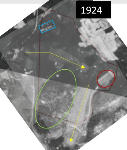

Ø 1935: construction of bunker and golf shop
Ø 1950s: construction of new tees and new bunkers, reconstruction of holes, tree planting
|
|
Figure 21-1956 aerial photograph shows mainly additional bunkers, drainage system around (new?) green for Hole 1 and a new area in front of the Ladies Pavilion.
Key:
|
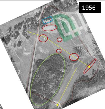

Ø 1960: pump and the piping system for all greens
|
|
Figure 22-1964 aerial photograph showing impacts for the first time within the tree cluster to the west of Hole 2. The trees to the northwest of Hole 1 green appears fuller, while an area to the north of this appears barren and ‘under construction’.
Key:
|
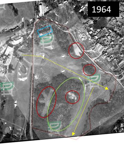
Ø 1970s: new lay-out, including re-aligning 1-4 holes, new 5 hole, trees cut and replanting of trees, new pond and draining of bog, car park
|
|
Figure 23-1977 aerial photograph show the realignment and associated construction of Holes 1, and 2 and 3 fairways through the western tree cluster and new Hole 3 Green. The trees to the southeast of the Ladies Pavilion have been largely removed, the construction of the carpark has commenced and extends into the western tree cluster. Note the sparse cover of the northern part of the western tree cluster.
Key:
|
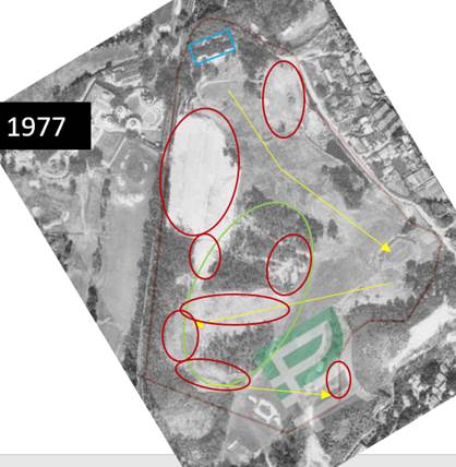
Ø 1983: Fanling pumping station, tennis courts
Ø 1985: construction of Senior Staff Houses at Ladies Pavilion
|
|
Figure 24-1985 aerial photograph show the construction of the senior staff houses at the former Ladies Pavilion. To the south east of this the tennis court are finished. The car park seems operational and the northern end of the western tree cluster appears regenerated. Artificial construction of tee off and green areas for Hole 2 appear clearly and fairway is more defined (manicured). Note the construction of the pumping station to the south and housing to the southeast of the Development Option boundary.
Key:
|
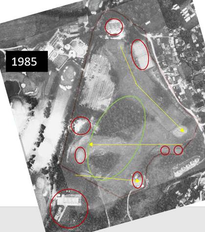
Ø 2000s: paved roads
Ø 2012: new irrigation system
|
|
Figure 25-2020 aerial photograph shows clearly the irrigations system below the fairways. The northern end of the western tree cluster, once more is partially removed for what looks like grass nursery and the paths around the golf course have been paved.
Key:
|
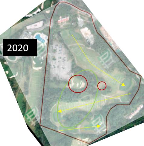

12.6.2.3 The field visit revealed ‘unnatural contouring’ further indicating modifications to the original landform. The following photos taken from HKGC website (Figures 26-34) illustrate the modifications.
|
|
Figure 26-Current layout of Hole 1 within the Old Course with tee off at no.1 in the north and playing south to the green surrounded by the (blue) drain. |
||
|
|
|||
|
Figure 27-Drainage channel around green of Hole 1; looking southwest. Note the heigh differences looking south. |
|||
|
|
|||
|
Figure 28-View of the fairway of Hole 1 looking generally south. |
|||
|
|
Figure 29-View of tee off and fairway of Hole 2 playing east to west through the western tree cluster |
||
|
|
|||
|
Figure 30-Green of hole 2 looking toward tee of Hole 3 with part of the western tree cluster to the left (centre area) |
|||
|
|
|||
|
Figure 31-View from geen of Hole 2 to east through the western tree cluster; note how the topography of the fairway largely follows the tree clusters although previous photo shows some cutting of original topography. |
|||
|
|
Figure 32-Hole 3 fairway was also carved within the western tree cluster and generally west east oriented (with slight slant to south) |
||
|
|
|||
|
Figure 33-Green of Hole 3 carved out of lower hill slope, note unnatural contours and bunker |
|||
|
|
|||
|
Figure 34-View of Hole 3 fairway through the western tree cluster with fairway of Hole 2 on the right and the remaining trees on a slighlty raised area in between |
|||
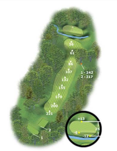
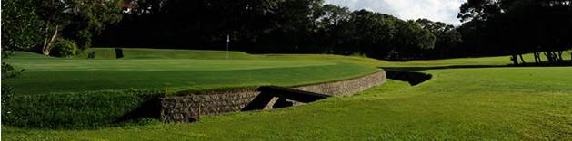
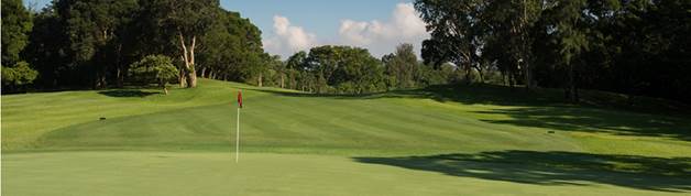
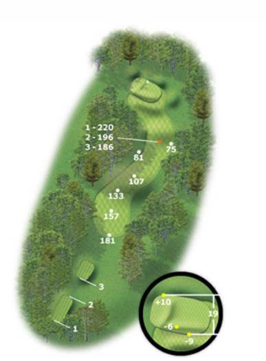
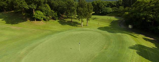
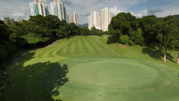
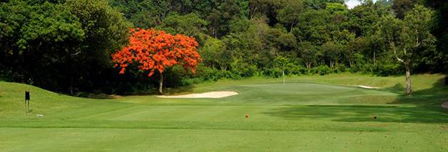
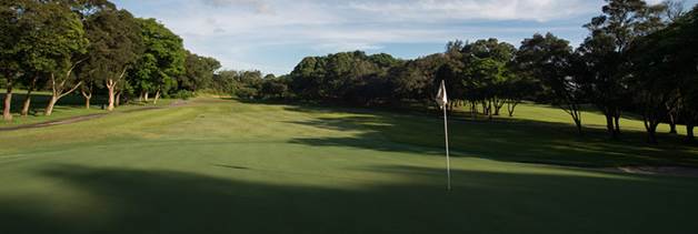
12.6.2.4 The existing impacts have affected large parts of Sub-Area 1 with the exception of pockets within the western tree cluster. Figure 35 shows the three areas which remained unaffected by construction of golf course and course changes and improvements since 1911 . Field visit as shown in the photographs (Figures 36-38) indicate that the soil cover on these raised areas is thin while rock is visible on the surface.
|
|
|
|
Figure 35-Map showing likley unaffected areas within the Sub-Area 1 (western tree cluster) with some potential for archaeology.
|
|
|
|
|
|
Figure 36-Tree cluster to the north of fairway of Hole 2; view of collapsed tree. Note the shallow roots and thin soil cover. |
|
|
|
|
|
Figure 37-Tree cluster to the south of fairway of Hole 3; view of collapsed trees. Note the shallow roots and thin soil cover.
|
|
|
|
Figure 38-Tree cluster area to the north of Fairway of Hole 2; note rock on surface. |
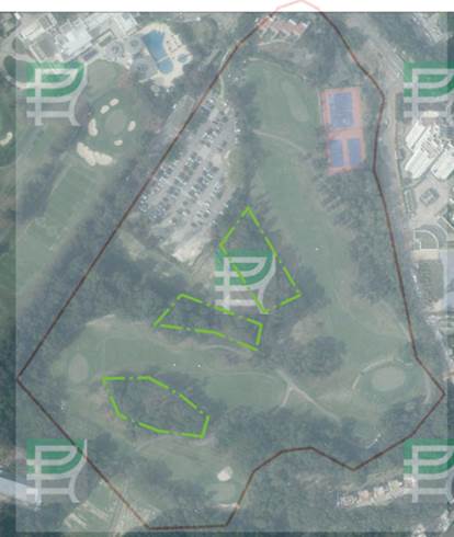
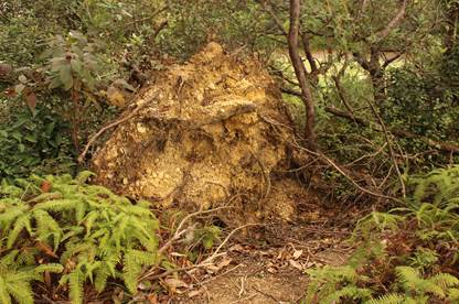
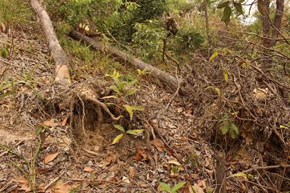
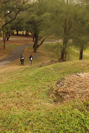
12.6.3 Assessment of existing impacts within Sub-Areas 2 to 4
12.6.3.1 The existing impacts are similar to those within Sub-Area 1. Initially, here too the fairways crossed Fan Kam Road and were later redesigned. There is evidence for minor hill cutting, construction of drainage in the fairways, bunkers, new tees and greens, ponds/swamp, etc.
12.6.3.2 Within Sub-Area 2, outside of the existing impacts, is a small area to the south with trees which may have been excluded from development. Within Sub-Area 3 an original hillock with trees was cut by 1980, but two areas remain relatively untouched based on aerial photograph review. Finally, within Sub-Area 4, is a triangular wooded area which remained untouched. It, however, is an ecological sensitive area and is off limits for development and excavation. The pockets of original landform within Sub-Areas 2 to 4 are marked on Figure 39. At this stage, the areas of original landform are excluded from the proposed minor works.
|
|
|
Figure 39-View of pockets of original landform within Sub-Areas 2 to 4; note the triangular wooded area within Sub-Area 4 on the right; the two central marked areas are within Sub-Area 3 and finally the area to the left marks the end of Sub-Area 2. (detail of 2019 aerial photograph, Lands Department Ref: E078524C) |
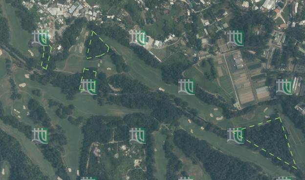
12.6.4 Assessment of archaeological impacts
12.6.4.1 The construction for Sub-Area 1 and minor works in Sub-Areas 2 to 4 may involve, at minimum, site formation which generally will adversely affect any potential archaeology if present. The desk-based review indicates that some archaeological potential exists within the PDA and Study Area which includes:
· Po Leng Site of Archaeological Interest (SAI) will not be affected by the proposed works and lies at sufficient distance (>150m) from the PDA. The sparse Tang/Song dynasty finds were recorded in the northwest tip of the SAI.
The materials, however, were not recorded in defined context and the exact location of deposit, activity or settlement are unknown. The PDA is topographically significantly lower and perhaps more suitable for agricultural use than settlement. In addition, the findings are separated from the PDA by a stream course and a hillock, Pei Tau Ling Kok; it is not expected that the finds extend into the PDA.
Some of the associated infrastructure works, including construction of flood wall are located at the edge of the boundary of Po Leng Site of Archaeological Interest.
· The area of archaeology findings near the (existing) historical village of Ping Kong is highly likely associated with the founding of Ping Kong in the late Ming to early Qing dynasty. It is unlikely that major findings extend into the PDA. The findings are around 100m from the PDA boundary and hillock Pei Tau Ling Kok lies between the findings and Sub-Area 1. Some of the associated infrastructure works, including construction of flood wall are located around 100m to the northeast of the findings.
12.6.4.2 Sub-Area 1 is situated within the golf course and away from the previous archaeological findings. The following Table 8 summarizes the option, desk-based results, assessment.
Table 12.7 Summary of desk-based results for PDA and Study Area assessment
|
Study Area |
Desk-based results |
Assessment
|
|
Associated infrastructure for Sub-Area 1 including road modifications and utility, including drainage, sewage and water mains provisions.
Figure 1001 |
The proposed works are mainly in the north, northeast and east of Sub-Area 1. The areas to the north and north east of Fanling Highway have been disturbed (see Figure 2) and proposed associated work along the existing roads and residential development are likely disturbed. Previous archaeological testing, however, was conducted to the east of Sub-Area 1 with Tang/Song dynasty finds around proposed drainage and minor road upgrades. |
Previous archaeological findings near the associated infrastructure works to the east of Sub-Area 1 suggest archaeological potential but currently infrastructure works are proposed within existing roads and drainage channel. Depending on details of proposed works and exact locations to be reviewed in detailed archaeological impact assessment at later stage (and prior to detailed design stage), an archaeological field survey (prior to construction phase) or archaeological watching brief (during construction phase) may be required. |
|
Remainder of the Study Area with minor works and possible associated infrastructure |
Po Leng Site of Archaeological Interest is located over 150m from the PDA boundary. In addition, the findings at Ping Kong are located around 100m from the boundary of the PDA. No other archaeological information exists within the Study Area. |
Although minor works is proposed, some potential for archaeology cannot be excluded on elevated areas alongside the fairways or associated works areas (TBD).
|
|
PDA (Sub-Area 1)
|
Desk-based results |
Assessment |
|
School and public housing development
Figure 8 |
The proposed housing is located 150m from 1999 Tang/Song dynasty findings in Po Leng SAI. Topographically Sub-Area 1 is separate by now channelled stream and some hillocks. Development area would have consisted of flat and terraced agricultural fields and hillocks with burials. Existing impacts within the golf course have been ongoing since 1911 and include, filling in of original ponds and pools, construction of ponds, bunkers, fairways, tees, holes, planting and cutting of trees, ancillary structures and irrigation system. The school complex is proposed on the location of the previous Ladies Pavilion. The area has documented disturbance through the construction of the tennis fields and
|
The original topography and geology of Sub-Area 1 would have been similar to areas of previous archaeological findings in the Study Area.
The existing impacts within the golf course, however, have been ongoing since 1911 and have adversely and irreversibly impacted on potential archaeology. See Section 6.2 for impacts which include for instance construction and demolition of Ladies Pavilion, construction of staff housing and tee off for Hole 1, construction of tennis courts at the proposed school location. Therefore, the presence of widespread archaeology is unlikely.
Despite the disturbance by the golf course, pockets of original topography may remain within the Sub-Area 1 area. (Section 6.2) (Figure 35)
|
|
PDA (Sub-Areas 2-4)
|
Desk-based results |
Assessment
|
|
Minor works is proposed |
There are no known sites of archaeological interest within the PDA (Sub-Areas 2-4). The original geological and topographical situation may have included archaeological information. Ongoing construction and maintenance of the golf course (similar to Sub-Area 1) would have affected potential. |
Although minor works is proposed, some potential for archaeology cannot be excluded (similar to Sub-Areas 1 on elevated areas alongside the fairways). (Figure 39)
|
12.6.5 Archaeological mitigation recommendations
12.6.5.1 The existing impacts within the Sub-Area 1 and Sub-Areas 2 to 4, including construction and maintenance of the golf course, graves and tree planting will have affected the archaeological potential. Therefore, the presence of widespread archaeology within the PDA, i.e Sub-Area 1 and Sub-Areas 2 to 4 is unlikely. Archaeological potential would have been affected by existing construction, modification and maintenance impacts associated with golf course construction and maintenance. Regardless, archaeological potential cannot be excluded based solely on desk-based information and a detailed archaeological impact assessment including archaeological field survey, including field scan, auger tests and test pit excavation will be required within Sub-Area 1 and select areas within Sub-Areas 2 to 4 if development is confirmed at Investigation Phase (and prior to detailed design stage) and if works will affect in areas with no or limited existing impacts (Section 6.2). The archaeological survey and archaeological impact assessment should be conducted prior to other investigations including ground investigation, investigation for land contamination and so on in order not to disturb the site and the archaeological field survey.
12.6.5.2 Currently, FGC is in operation with active golf activities. In consideration of safety of the public and the archaeologist for conducting the archaeological survey, it is proposed to conduct archaeological field survey after the land is handed over to the Project Proponent so as to obtain the most up-to-date findings for archaeological assessment. Based on the result of the detailed archaeological impact assessment, mitigation measures, if necessary, should be recommended in prior agreement with AMO. No construction works would be commenced prior to completion of the detailed archaeological impact assessment and the agreement of mitigation measures if needed.
12.6.5.3 In addition, some archaeological potential exist around the proposed drainage and minor road upgrade works to the east of Sub-Area 1 or as yet decided works associated with minor works in Sub-Areas 2 to 4, although the some of the proposed impacts will occur on and along existing roads and drainage channels. Depending on the details of the proposed associated and/or drainage and minor road upgrade works to be reviewed in detailed archaeological impact assessment at later stage (and prior to detailed design stage), an archaeological field survey (prior to construction phase) is required if areas outside the existing roads and drainage channels are affected, or archaeological watching brief (during construction phase) is required if works are within existing impact areas such as existing roads and drainage channels. Review should be undertaken for Sub-Area 1 and Sub-Areas 2 to 4 (associated) works prior to other investigations including ground investigation, investigation for land contamination and so on in order not to disturb the site.
12.7 Conclusion and summary
12.7.1 The desk-based review and built heritage survey identified a number of graded, not-graded historic buildings and clan graves alongside the Fanling Golf Course (New Item) within the Study Area. Two Graded historic buildings, Grade 2 Clubhouse of The Hong Kong Golf Club Fanling Golf Course and Grade 3 Half-way House of of The Hong Kong Golf Club Fanling Golf Course, and six clan graves may be indirectly affected by the proposed development option. One clan grave (G-01) will require relocation. Mitigation recommendations include possible green screening for the two graded historic buildings depending on the final location, design and height of the development and further measures, such as condition survey, monitoring, implementing buffer zones and ensuring safe public access, may be required during the construction phase for the clan graves. For all the graded, not-graded historic buildings and clan graves, the overall impact is ranging from Acceptable to Acceptable with mitigation.
12.7.2 The desk-based review indicated that there is unlikely a presence of widespread archaeology within the PDA, i.e. Sub-Area 1 and Sub-Area 2 to 4. Archaeological potential would have been affected by the existing construction, modification and maintenance impacts associated with the golf course construction and maintenance. Regardless archaeological potential cannot be excluded based solely on desk-based information although existing impact areas have been identified in Section 6.2. A detailed archaeological impact assessment including an archaeological field survey within Sub-Area 1 and select areas within Sub-Area 2 to 4 will be carried out in later stage. Currently, FGC is in operation with active golf activities. In consideration of safety of the public and the archaeologist for conducting the archaeological survey, it is proposed to conduct archaeological field survey after the land is handed over to the Project Proponent so as to obtain the most up-to-date findings for archaeological assessment. Based on the result of the detailed archaeological impact assessment, mitigation measures, if necessary, should be recommended in prior agreement with AMO. No construction works including ground investigation, investigation for land contamination and so on, would be commenced prior to completion of the detailed archaeological impact assessment and the agreement of mitigation measures if needed.
12.7.3 Review of the location and method of constructing associated infrastructure to the east of the Sub-Area 1 and any associated works areas of Sub-Areas 2 to 4 should be undertaken in detailed archaeological impact assessment at later stage (and before the detailed design stage) and prior to construction, including ground investigation, investigation for land contamination and so on, to determine appropriate mitigation, such as an archaeological field survey (prior to construction phase) or archaeological watching brief (during construction phase).
12.7.4 Further assessment pending to the grading of the New Item conducted by AAB and mitigation measures, where necessary, will be proposed to AMO for agreement.
12.8 Bibliography and references
AAB (2019a) Historic Building Appraisal- Fanling Lodge, Kwu Tung, Sheung Shui, N.T. Last revision date: 6 December 2019. Accessed on 25.05.2020
AAB (2019b) Historic Building Appraisal- The Clubhouse, Hong Kong Golf Club Fanling Golf Course, Fan Kam Road, Fanling, N.T. Last revision date: 6 December 2019. Accessed on 25.05.2020
AAB (2019c) Historic Building Appraisal- Half-way House, The Hong Kong Golf Club Fanling Golf Course, Fan Kam Road, Fanling, New Territories. Accessed on 25.05.2020
AAB (2020) Historic Building Appraisal – No.5 Ng Uk Tsuen, Sheung Shui New Territories. Accessed on 25.05.2020.
AMO (2018) Liu Man Shek Tong Ancestral Hall (pamphlet).
AMO GIS Online (2019) Hong Kong’s Heritage. Accessed on 28.11.2019.
Appendix Q: Report of the Director for Public Works for the Year 1933 (Hong Kong Government Annual Report) 1933.
陳天權 (2012) 《香港節慶風俗》, 香港:明報出版社。(Chan 2012)
周子峰 (2010)《圖解香港史:遠古至一九四九年》,香港:中華書局。(Chau 2010)
CUHK (2009) Hong Kong History and Society: Liu genealogical records. Accessed 19th March 2020.
Donnelley, Paul (2010) Firsts, Lasts & Onlys of Golf: Presenting the most amazing golf facts from the last 600 years. London: Octopus Publishing Group.
European Institute of Golf Course Architects (EIGCA) (2017) Golf Courses as Designed Landscapes of Historic. Research Report Series no. 42-2017. Historic England.
Fanling Golf Club (2019) Background Information of Lung Yeuk Tau and Tai Tau Leng.
Graves Robert Muir & Geoffrey S. Cornish (1998) Golf Course Design. New York: J. Wiley. Pp.189.
Hase, Patrick (2014) The Six-Day war of 1899: Hong Kong in the age of imperialism. / 《被遺忘的六日戰爭:1899年新鄉民界與英軍之戰》。香港:中華書局。
Hayes, James (2012) The Great Difference: Hong Kong’s New Territories and Its People 1898-2004. Hong Kong: Hong Kong University Press.
Heung Yee Kuk N.T. (1989) List of Established Villages in the New Territories (Ref.BLD19/4073/89).
HKIA (2002) Agreement No. CE109/98, Deep Bay Link, Investigation and preliminary design, CHIA report.
HKIA (2002) 《2001年新界北區擬擴建排污渠工程(合約1)考古調查及評估報告》,AMO reference code ND21.
HKGC / Hong Kong Golf Club (2018a) Heritage. Accessed on 21.10.2019.
HKGC / Hong Kong Golf Club (2018b) Facts and Figures. Accessed on 15.10.2019.
HKGC Website (2018) Old Course – Fanling. Assessed from: https://www.hkgolfclub.org/cms/courses-facilities/fanling/courses/old-course/
Assessed on 31.12.2020.
HKGC / Hong Kong Golf Club (2018b) Facts and Figures. Accessed from: https://www.hkgolfclub.org/cms/the-club/facts-figures/. Accessed on 15.10.2019.
何惠清 (2016)《新界六大家族》,香港:博學出版社。(Ho 2016)
Hong Kong Golf Club. Club History. Accessed on 28.11.2019.
Hong Kong Memory (2012) Tai Ping Hung Chiu. Accessed on 15.10.2019.
KGC Website/ Kobe Golf Club (2018a) History. Accessed from:
http://www.kobegc.or.jp/english/#wrapper
Accessed on 29.12.2020.
KGC Website/ Kobe Golf Club (2018b) Course Guide. Accessed from: http://www.kobegc.or.jp/english/#course-eng
Lau, Chi-pang / 劉智鵬 (2019) 《香港哥爾夫球會走過的130年》/ The Hong Kong Golf Club,香港:三聯書店。
Leung, Hui Wah / 梁煦華 (2002) 《穿村: 鄉郊歷史傳聞與鄉情》,香港:天地圖書有限公司。
Li, Yue Sing and Lau, Yip Kau (1999) 《香港粉嶺三十六區考古調查評估報告》,AMO reference code ND12.
馬金科 (2018)《早期香港史研究資料選輯》,第一輯,香港:三聯書店(香港)有限公司。(Ma 2018)
ONC Lawyers (1961) New Memorandum and Articles of Association of Fung Kai Public School[鳳溪公立學校]. Accessed 13.03.2020.
PRO / Public Record Office (1913) Royal Hong Kong Golf Club, Fanling, 9 June 1913. (showing appr. Area of proposed building and cultivated land). Code: map CO-129-401.pp296-297.
PRO / Public Record Office (1916) The May Family and Friends golfing at Fanling, 1916. Code: 8-19C-351 to 365.
RCGC Website / Royal Calcutta Golf Club (2015a) History. Accessed from:
https://www.rcgc.in/golf_course/history.php
Accessed on 29.12.2020.
RCGC Website / Royal Calcutta Golf Club (2015b) The Royal Charter. Accessed from:
https://www.rcgc.in/golf_course/royal_charter.php
Accessed on 29.12.2020.
Robinson, Spencer (1989) Festina Lente: 粉嶺: a history of The Royal Hong Kong Golf Club. Hong Kong: The Royal Hong Kong Golf Club.
Spence, James (2005) The Finest Golf Courses of Asia & Australasia. Hong Kong: The First Shot Press Limited.
田仲一成著,錢杭、 任余白譯 (2019)《中國的宗族與演劇》。三聯出版社。(Tanaka 2019)
Tam, Siman / 譚思敏 (2012) 《香港新界侯族的建構 : 宗族組織與地方政治和民間宗教的關係》,香港:中華書局(香港)有限公司。
Waters, T.F.R. (1960) History of the Royal Hong Kong Golf Club. Hong Kong: South China Morning Post Ltd.
Web source (2014) Royal Calcutta Golf Club. Tollygunge (since 1910), 1829. From Blog puronokolkata Calcutta: as she was – a visual documentation of socio-cultural ethos spanning over three centuries. Published on online June 30, 2014. Assessed from:
https://puronokolkata.com/2014/06/30/royal-calcutta-golf-club-tollygunge-since-1910-1829/. Accessed on 29.12.2020.
Web source (no date) Royal Calcutta Golf Club. Accessed from:
https://golfproperty.com/golf-course/royal-calcutta-golf-club/
Accessed on 29.12.2020.
Ming Pao / 明報 (2019)《高球場140頃續租至2027年 32公頃建屋 2024年可變「熟地」》,發表於2019年2月21日星期四。Accessed on 24.03.2020.
Xie, Jian & Ford, David / 謝劍、科大衛 (2005) 《香港客家/客家研究》,廣西師範大學出版社。
Reviewed Maps
Great Britain, Ordnance Survey Office (1914) Hong-Kong-New-Territory. HF Sheet 2&5. Scale 2 inches to one mile. Prepared and printed at the Ordnance Survey Office, Southampton.
Great Britain, War Office, Geographical Section, General Staff (1945) Hong Kong and New Territory, Tai Po. GSGS3868, Sheet 11, HB-6. Scale 1:20000. Published by the War Office, 1929. Additional names 1934. 2nd Edition 1945 (Grid change only, 1945).
Great Britain, War Office, Geographical Section, General Staff (1945) Hong Kong and New Territory, San Tin. GSGS3868, Sheet 10, HB-6. Scale 1:20000. Published by the War Office, 1929. Additional names 1934. 2nd Edition 1945 (Grid change only, 1945).
Crown Lands and Survey Office (1959) Topographic map. Scale one inch to 100 feet or 1:1200m. Sheet 76-NW-D. Published by the Ordnance Survey office.
Crown Lands and Survey Office (1961), Topographic map. Scale one inch to 100 feet or 1:1200m. Sheet 76-SW-B. Published by the Ordnance Survey office.
Crown Lands and Survey Office (1967) Area 4, Fanling. Scale [ca. 1:9,600], 800 feet to one inch. Hong Kong: Public Works Department.
Crown Lands and Survey Office (1968), Topographic map. Scale one inch to 100 feet or 1:1200m. Sheets 76-NW-D and 76-SW-B. Published by the Ordnance Survey office.
Crown Lands and Survey Office (1975) Topographic map. Scale 1:1000m. Sheet 3-SW-11C. Published by Survey and Mapping Office, Lands Department.
Crown Lands and Survey Office (1975) Topographic map. Scale 1:1000m. Sheet 3-SW-11A. 2nd Edition. Published by Survey and Mapping Office, Lands Department.
Crown Lands and Survey Office (1976) Topographic map. Scale 1:1000m. Sheet 13-SW-6C. Published by Survey and Mapping Office, Lands Department.
Crown Lands and Survey Office (1985) Topographic map. Scale 1:1000m. Sheet 3-SW-6C. Published by Survey and Mapping Office, Lands Department.
Crown Lands and Survey Office (1986) Topographic map. Scale 1:1000m. Sheet 3-SW-11A. Published by Survey and Mapping Office, Lands Department.
Crown Lands and Survey Office (1987) Topographic map. Scale 1:1000m. Sheet 3-SW-11C. 4th Edition. Published by Survey and Mapping Office, Lands Department.
Land Department Aerial photographs reviewed for assessment of Sub-Areas 2-4
1956 Ref: F21_564-0053
1964 Ref: 4019
1964 Ref: 4023
1977 Ref: 20176
1978 Ref: 22866
1984 Ref: 22866
1986 Ref: A04679
1990 Ref: A21910
1980 Ref: A04679
2019 Ref: E078524C